IMAGES TAKEN NEAR TO
Hollins Square, BURY, BL9 8DH
Introduction
This page details the photographs taken nearby to Hollins Square, BL9 8DH by members of the Geograph project.
The Geograph project started in 2005 with the aim of publishing, organising and preserving representative images for every square kilometre of Great Britain, Ireland and the Isle of Man.

There are currently over 7.5m images from over14,400 individuals and you can help contribute to the project by visiting https://www.geograph.org.uk
Image Map
Images are licensed for reuse under creativecommons.org/licenses/by-sa/2.0
Notes
- Clicking on the map will re-center to the selected point.
- The higher the marker number, the further away the image location is from the centre of the postcode.
Image Listing (41 Images Found)
Images are licensed for reuse under creativecommons.org/licenses/by-sa/2.0
Image
Details
Distance
1
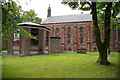
The Parish Church of St George, Unsworth
Image: © Alexander P Kapp
Taken: 19 Sep 2005
0.01 miles
5
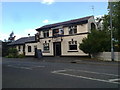
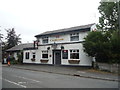
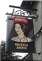
The Queen Anne
Another pub which depends on food for its business.
Image: © Bill Boaden
Taken: 27 Jul 2010
0.04 miles
7
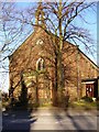
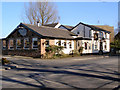
Parish Church of Saint George, Hollins Lane, Unsworth
Image: © David Dixon
Taken: 7 Mar 2010
0.05 miles
8
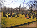
St George's Cemetery
Off Hollins Lane, Unsworth.
Image: © David Dixon
Taken: 7 Mar 2010
0.05 miles
9
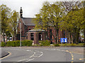
St George's Parish Church, Unsworth
The Parish Church of St George is at the junction of Hollins Lane and Castle Road at Unsworth.
Image: © David Dixon
Taken: 3 May 2012
0.05 miles
10
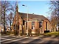
St George's Parish Church, Unsworth
On Hollins Lane, Unsworth.
Image: © David Dixon
Taken: 7 Mar 2010
0.05 miles