IMAGES TAKEN NEAR TO
Bury & Rochdale Old Road, BURY, BL9 7TT
Introduction
This page details the photographs taken nearby to Bury & Rochdale Old Road, BL9 7TT by members of the Geograph project.
The Geograph project started in 2005 with the aim of publishing, organising and preserving representative images for every square kilometre of Great Britain, Ireland and the Isle of Man.

There are currently over 7.5m images from over14,400 individuals and you can help contribute to the project by visiting https://www.geograph.org.uk
Image Map
Images are licensed for reuse under creativecommons.org/licenses/by-sa/2.0
Notes
- Clicking on the map will re-center to the selected point.
- The higher the marker number, the further away the image location is from the centre of the postcode.
Image Listing (18 Images Found)
Images are licensed for reuse under creativecommons.org/licenses/by-sa/2.0
Image
Details
Distance
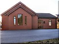
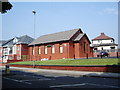
1
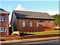
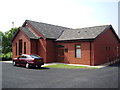
Jericho Methodist Church
View from Rochdale old Road.
Image: © David Dixon
Taken: 1 Mar 2010
0.05 miles
5
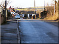
Elbut Lane
Leading towards Elbut Farm and Mill, and beyond to Birtle.
Image: © David Dixon
Taken: 1 Mar 2010
0.06 miles
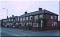
8
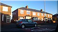
Houses on Rochdale Old Road, Jericho
Post-war housing on Rochdale Old Road in Jericho area of Bury, Greater Manchester, England.
Image: © Steven Haslington
Taken: 17 Dec 2013
0.10 miles
9
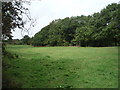
Grazing and woodland off Bury and Rochdale Old Road
Image: © JThomas
Taken: 17 Sep 2018
0.14 miles
10
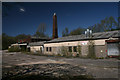
Tack Lee Bleach Works
The former Tack Lee bleach works.
Image: © Peter McDermott
Taken: 18 Apr 2014
0.20 miles