IMAGES TAKEN NEAR TO
Bury Old Road, BURY, BL9 7JG
Introduction
This page details the photographs taken nearby to Bury Old Road, BL9 7JG by members of the Geograph project.
The Geograph project started in 2005 with the aim of publishing, organising and preserving representative images for every square kilometre of Great Britain, Ireland and the Isle of Man.

There are currently over 7.5m images from over14,400 individuals and you can help contribute to the project by visiting https://www.geograph.org.uk
Image Map
Images are licensed for reuse under creativecommons.org/licenses/by-sa/2.0
Notes
- Clicking on the map will re-center to the selected point.
- The higher the marker number, the further away the image location is from the centre of the postcode.
Image Listing (17 Images Found)
Images are licensed for reuse under creativecommons.org/licenses/by-sa/2.0
Image
Details
Distance
1
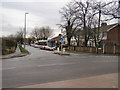
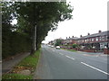
Bury Old Road
Bury Old Road at the junction with Heap Brow and Moss Hall Road.
Image: © David Dixon
Taken: 4 Feb 2010
0.03 miles
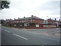
2
Row of three houses at Heap Brow
Seen from the East Lancs Railway.
Image: © Christine Johnstone
Taken: 6 Sep 2018
0.09 miles
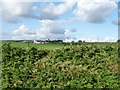
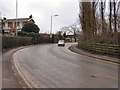
4
Bury Old Road towards Heywood
Looking north east.
Image: © JThomas
Taken: 10 Sep 2018
0.10 miles
5
Heap Brow
View looking up Heap Brow, taken in 1978. Compare this with Image], taken in 2010. Little has changed in 30 years!
Image: © David Dixon
Taken: Unknown
0.11 miles
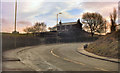
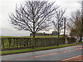
6
Heap Brow
Looking uphill towards Bury Old Road.
Compare this view with Image] taken 30 years previously.
Image: © David Dixon
Taken: 4 Feb 2010
0.12 miles
7
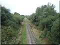
East Lancashire Railway
Looking west from the bridge on Moss Hall Road.
Image: © JThomas
Taken: 10 Sep 2018
0.15 miles
8
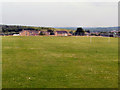
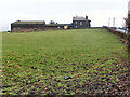
Heywood Community School Playing Fields, July 2010
Sutherland High School, on Sutherland Road at Darnhill, was opened in 1966. Its name was changed to Heywood Community School in the 1990s. The school closed in June 2010 (http://menmedia.co.uk/heywoodadvertiser/news/s/1193762_school_party_to_mark_the_end_of_an_era - Heywood Advertiser and http://news.bbc.co.uk/local/manchester/hi/people_and_places/newsid_8940000/8940501.stm - BBC Education), and was demolished during the winter of 2010-11.
Image: © David Dixon
Taken: 19 Jul 2010
0.16 miles
9
Bury Old Road
Looking towards Heap Fold Farm.
Image: © David Dixon
Taken: 4 Feb 2010
0.17 miles