IMAGES TAKEN NEAR TO
Elm Street, BURY, BL9 7DD
Introduction
This page details the photographs taken nearby to Elm Street, BL9 7DD by members of the Geograph project.
The Geograph project started in 2005 with the aim of publishing, organising and preserving representative images for every square kilometre of Great Britain, Ireland and the Isle of Man.

There are currently over 7.5m images from over14,400 individuals and you can help contribute to the project by visiting https://www.geograph.org.uk
Image Map
Images are licensed for reuse under creativecommons.org/licenses/by-sa/2.0
Notes
- Clicking on the map will re-center to the selected point.
- The higher the marker number, the further away the image location is from the centre of the postcode.
Image Listing (67 Images Found)
Images are licensed for reuse under creativecommons.org/licenses/by-sa/2.0
Image
Details
Distance
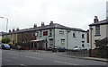
1
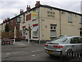
Roach Hotel. 331 Rochdale Road - Bury - BL9 7BX
Image: © Robert Wade
Taken: 3 Jun 2009
0.02 miles
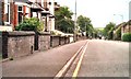
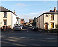
3
Beech Street, Bury
On the north side of the A58 Rochdale Road.
Image: © Jaggery
Taken: 6 Oct 2013
0.04 miles
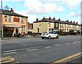
4
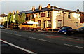
Roach Hotel, Bury
Pub at 331 Rochdale Road, on the corner of Deal Street.
Image: © Jaggery
Taken: 6 Oct 2013
0.04 miles
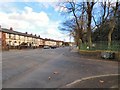
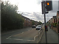
6
Rochdale Road, Pimhole
The A58 out of Bury. On the left is the Roach Hotel.
Image: © Gerald England
Taken: 4 Feb 2017
0.04 miles
7
Rochdale Road, Pimhole
The A58 out of Bury near Openshaw Park.
Image: © Gerald England
Taken: 4 Feb 2017
0.05 miles
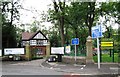
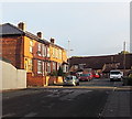
9
Wash Lane, Bury
An important route giving access from the M66 Motorway to north Bury.
Image: © Bill Boaden
Taken: 28 Jul 2010
0.05 miles
10
Myrtle Street South, Bury
Viewed across the A58 Rochdale Road.
Image: © Jaggery
Taken: 6 Oct 2013
0.06 miles