IMAGES TAKEN NEAR TO
Barlow Close, BURY, BL9 6WF
Introduction
This page details the photographs taken nearby to Barlow Close, BL9 6WF by members of the Geograph project.
The Geograph project started in 2005 with the aim of publishing, organising and preserving representative images for every square kilometre of Great Britain, Ireland and the Isle of Man.

There are currently over 7.5m images from over14,400 individuals and you can help contribute to the project by visiting https://www.geograph.org.uk
Image Map
Images are licensed for reuse under creativecommons.org/licenses/by-sa/2.0
Notes
- Clicking on the map will re-center to the selected point.
- The higher the marker number, the further away the image location is from the centre of the postcode.
Image Listing (30 Images Found)
Images are licensed for reuse under creativecommons.org/licenses/by-sa/2.0
Image
Details
Distance
2
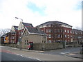
Hamilton Place
Built on the site of the old Bury General Hospital on Walmersley Road is Hamilton Place.
The old lodge house has been retained as part of the new development.
Image: © Paul Anderson
Taken: 3 Apr 2007
0.06 miles
3
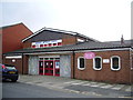
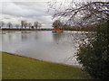
Community Centre
Within the Clarence Lido Park, run by Age Concern.
Image: © Peter Teal
Taken: 17 Jul 2008
0.07 miles
4
The Towler Inn, Walmersley Road, Bury
Image: © Alexander P Kapp
Taken: 13 Aug 2007
0.08 miles
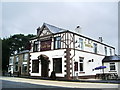
5
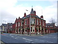
Sundial Hotel, Walmersley Road, Bury
Image: © Alexander P Kapp
Taken: 13 Feb 2008
0.09 miles
8
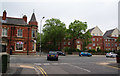
Where Arley Avenue meets Walmersley Road
The Sundial pub is an obvious landmark. To the right, the new housing is on the site of the former Bury General Hospital.
Image: © Bill Boaden
Taken: 6 Jun 2010
0.10 miles
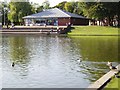
10
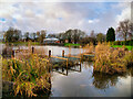
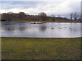
Clarence Park, The Lido
Clarence Park Lido started life as Walmersley Reservoir (ref: Bury Times 1 June 1963). In 1962 the water was drained from the then-reservoir and concrete walls replaced its boulder-strewn banking as it was converted to a “lido” ready for the summer of 1963. Although officially known as “Clarence Lido” (or “Bury Lido”) it might be better described as a lake.
Image: © David Dixon
Taken: 12 Dec 2020
0.10 miles