IMAGES TAKEN NEAR TO
Birtle Road, BURY, BL9 6UU
Introduction
This page details the photographs taken nearby to Birtle Road, BL9 6UU by members of the Geograph project.
The Geograph project started in 2005 with the aim of publishing, organising and preserving representative images for every square kilometre of Great Britain, Ireland and the Isle of Man.

There are currently over 7.5m images from over14,400 individuals and you can help contribute to the project by visiting https://www.geograph.org.uk
Image Map
Images are licensed for reuse under creativecommons.org/licenses/by-sa/2.0
Notes
- Clicking on the map will re-center to the selected point.
- The higher the marker number, the further away the image location is from the centre of the postcode.
Image Listing (4 Images Found)
Images are licensed for reuse under creativecommons.org/licenses/by-sa/2.0
Image
Details
Distance
2
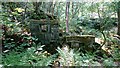
Kershaw Bridge Mill, Nabs Wife, Birtle
Kershaw Bridge was a fustian mill and one of the first mills to be built in the Cheesden Valley around 1780 by Thomas Allanson, and probably employed about 10 people. By the 1840s the mill was a dyeworks, but in 1845 it was taken over by the Whitehead family and converted for cotton production. In the early 1850s it became the first mill in the valley to cease production. Kershaw Bridge itself nearby was once a pack horse bridge. Now only the wheel pit remains.
Image: © John Westhead
Taken: 24 May 2018
0.12 miles
4
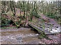
Cheesden Brook, Kershaw Bridge
Cheesden Brook near the footbridge at Nabs Wife, Kershaw Bridge looking south-east downstream to the beginning of Ashworth Valley
Image: © John Westhead
Taken: 14 Sep 2020
0.18 miles