IMAGES TAKEN NEAR TO
Kelwood Avenue, BURY, BL9 6TP
Introduction
This page details the photographs taken nearby to Kelwood Avenue, BL9 6TP by members of the Geograph project.
The Geograph project started in 2005 with the aim of publishing, organising and preserving representative images for every square kilometre of Great Britain, Ireland and the Isle of Man.

There are currently over 7.5m images from over14,400 individuals and you can help contribute to the project by visiting https://www.geograph.org.uk
Image Map (Loading...)


Getting Data...Please wait
Leaflet Map data © OpenStreetMap
Images are licensed for reuse under creativecommons.org/licenses/by-sa/2.0
Notes
- Clicking on the map will re-center to the selected point.
- The higher the marker number, the further away the image location is from the centre of the postcode.
Image Listing (33 Images Found)
Images are licensed for reuse under creativecommons.org/licenses/by-sa/2.0
Image
Details
Distance
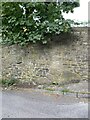
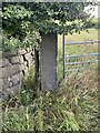
4
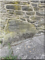
OS Cut Mark - Mawkin Farm, Castle Hill Road
Image: © thejackrustles
Taken: 17 Jul 2022
0.08 miles
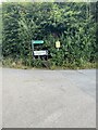
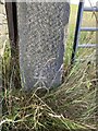
5
Location of OS Cut Mark - Mawkin Farm, Castle Hill Road
Image: © thejackrustles
Taken: 17 Jul 2022
0.08 miles
8
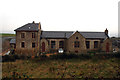
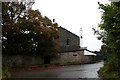
Birtle: Former school
The old primary school has been converted into high-end residential accommodation.
Image: © Dr Neil Clifton
Taken: 11 Oct 2012
0.13 miles
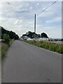
10
OS Cut Mark - Bury, Castle Hill Road
https://www.bench-marks.org.uk/bm106880
Image: © thejackrustles
Taken: 17 Jul 2022
0.14 miles