IMAGES TAKEN NEAR TO
Ribble Drive, BURY, BL9 6RS
Introduction
This page details the photographs taken nearby to Ribble Drive, BL9 6RS by members of the Geograph project.
The Geograph project started in 2005 with the aim of publishing, organising and preserving representative images for every square kilometre of Great Britain, Ireland and the Isle of Man.

There are currently over 7.5m images from over14,400 individuals and you can help contribute to the project by visiting https://www.geograph.org.uk
Image Map
Images are licensed for reuse under creativecommons.org/licenses/by-sa/2.0
Notes
- Clicking on the map will re-center to the selected point.
- The higher the marker number, the further away the image location is from the centre of the postcode.
Image Listing (23 Images Found)
Images are licensed for reuse under creativecommons.org/licenses/by-sa/2.0
Image
Details
Distance
2
A56, Walmersley
The A56, Walmersley Road, just to the north of Bury.
Image: © David Dixon
Taken: 18 Mar 2016
0.14 miles
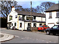
3
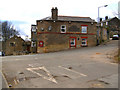
The New Inn, Walmersley Road, Bury
Image: © Alexander P Kapp
Taken: 13 Aug 2007
0.14 miles
4

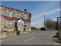
The New Inn, Walmersley Road
There is a banner on the pub stating it is under new management with London Town Pubs, but this company went into administration about 3 months ago and is trying to dispose of its pubs. It appears to be trading normally.
Image: © Bill Boaden
Taken: 6 Jun 2010
0.15 miles
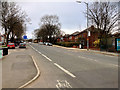
5

Walmersley Road, Bury
The road heads uphill out of Bury towards the M66 motorway exit and Shuttleworth. This is the first opportunity to do more than 30 mph this side of Bury.
Image: © Bill Boaden
Taken: 6 Jun 2010
0.18 miles
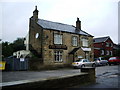
7
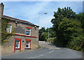
Masons Arms
The Masons Arms, on Walmersley Old Road, viewed from Bentley Lane.
Image: © David Dixon
Taken: 13 Mar 2010
0.19 miles
9
Masons Arms
Located on a sharp blind bend on Walmersley Old Road is the Masons Arms.
Carry on up this road and it takes you to Image
Image: © Paul Anderson
Taken: 7 Apr 2007
0.19 miles
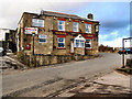
10
Mason's Arms, Baldingstone
This is the west elevation of the pub seen from the junction of Bentley Lane with Walmersey Old Road. The cobbled road past the pub leads over the M66 towards Nangreaves.
Image: © michael ely
Taken: 25 Jul 2008
0.20 miles