IMAGES TAKEN NEAR TO
Hudcar Lane, BURY, BL9 6HD
Introduction
This page details the photographs taken nearby to Hudcar Lane, BL9 6HD by members of the Geograph project.
The Geograph project started in 2005 with the aim of publishing, organising and preserving representative images for every square kilometre of Great Britain, Ireland and the Isle of Man.

There are currently over 7.5m images from over14,400 individuals and you can help contribute to the project by visiting https://www.geograph.org.uk
Image Map (Loading...)


Getting Data...Please wait
Leaflet Map data © OpenStreetMap
Images are licensed for reuse under creativecommons.org/licenses/by-sa/2.0
Notes
- Clicking on the map will re-center to the selected point.
- The higher the marker number, the further away the image location is from the centre of the postcode.
Image Listing (11 Images Found)
Images are licensed for reuse under creativecommons.org/licenses/by-sa/2.0
Image
Details
Distance
1
Salford Street Chesham
The trees to the left replace terraced houses which were demolished in recent years.
Image: © Dennis Turner
Taken: 1 Mar 2006
0.08 miles
2
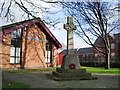
War Memorial at Salvation Army Hall, Bury
Image: © Alexander P Kapp
Taken: 13 Feb 2008
0.10 miles
3
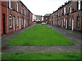
Duckworth Street Bury
May be it should be called Green Street.
The local council came up with this idea to stop cars from using the street as a short cut.
Local residents now have to park in nearby streets which is not so good if you have a lot of shopping etc to carry home.
For future reference the 2 bedroom house at the bottom of the street on the right was on the market for £99,950 in July 2007
Image: © Paul Anderson
Taken: 4 Jul 2007
0.15 miles
4
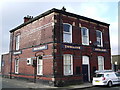
The Brickcroft, Brook Street, Bury
Image: © Alexander P Kapp
Taken: 13 Feb 2008
0.16 miles
5
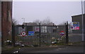
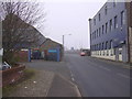
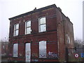
Abandoned Industrial Units, Brook Street
It appears the auction didn't tempt anybody.
Image: © Robert Wade
Taken: 20 Feb 2009
0.19 miles
8
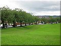
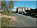
Chesham Road Bury
The tree lined Chesham Road runs along the southern edge of the playing fields of Chesham Park.
Image: © Paul Anderson
Taken: 4 Jul 2007
0.22 miles
9
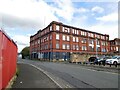
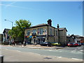
Old Mill on Bridge Street
On the corner of Cobden Street.
Image: © Gerald England
Taken: 30 Aug 2022
0.24 miles