IMAGES TAKEN NEAR TO
Ferngrove, BURY, BL9 6AT
Introduction
This page details the photographs taken nearby to Ferngrove, BL9 6AT by members of the Geograph project.
The Geograph project started in 2005 with the aim of publishing, organising and preserving representative images for every square kilometre of Great Britain, Ireland and the Isle of Man.

There are currently over 7.5m images from over14,400 individuals and you can help contribute to the project by visiting https://www.geograph.org.uk
Image Map (Loading...)


Getting Data...Please wait
Leaflet Map data © OpenStreetMap
Images are licensed for reuse under creativecommons.org/licenses/by-sa/2.0
Notes
- Clicking on the map will re-center to the selected point.
- The higher the marker number, the further away the image location is from the centre of the postcode.
Image Listing (6 Images Found)
Images are licensed for reuse under creativecommons.org/licenses/by-sa/2.0
Image
Details
Distance
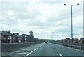
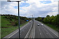
2
Limefield : M66 Motorway
Looking along the M66.
Image: © Lewis Clarke
Taken: 27 Sep 2019
0.10 miles
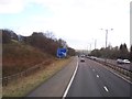
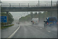
3
The M66 motorway
This is looking down the hill towards Bury. The uphill carriageway on the right has an extra lane for a short stretch, but I think this adds to rush-hour congestion.
Image: © Bill Boaden
Taken: 3 May 2010
0.19 miles
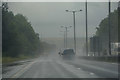
4
Limefield : M66 Motorway
Looking along the M66.
Image: © Lewis Clarke
Taken: 27 Sep 2019
0.24 miles