IMAGES TAKEN NEAR TO
The Drive, BURY, BL9 5DL
Introduction
This page details the photographs taken nearby to The Drive, BL9 5DL by members of the Geograph project.
The Geograph project started in 2005 with the aim of publishing, organising and preserving representative images for every square kilometre of Great Britain, Ireland and the Isle of Man.

There are currently over 7.5m images from over14,400 individuals and you can help contribute to the project by visiting https://www.geograph.org.uk
Image Map
Images are licensed for reuse under creativecommons.org/licenses/by-sa/2.0
Notes
- Clicking on the map will re-center to the selected point.
- The higher the marker number, the further away the image location is from the centre of the postcode.
Image Listing (21 Images Found)
Images are licensed for reuse under creativecommons.org/licenses/by-sa/2.0
Image
Details
Distance
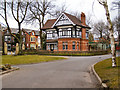
1
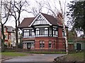
Clarence Park
This magnificent building may have been the park keeper's lodge in days of yore. It stands at the entrance to Clarence Park on the A56 at Bury.
Image: © Roger May
Taken: 27 Feb 2006
0.17 miles
2
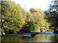
River Irwell
Taken from the bank looking down River at Burrs Country Park.
Image: © Paul Rudge
Taken: 25 Jun 2006
0.19 miles
3
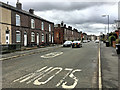
Bury, Hornby Street
Looking along Hornby Street towards the town centre.
Image: © David Dixon
Taken: 23 Mar 2018
0.19 miles
4
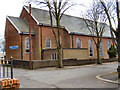
The Church of St John with St Mark, Seedfield
Image: © David Dixon
Taken: 13 Mar 2010
0.20 miles
7
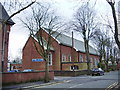
St John with St Mark Church, Sunny Avenue, Bury
Image: © Alexander P Kapp
Taken: 13 Feb 2008
0.20 miles
8
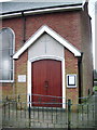
St John with St Mark Church, Sunny Avenue, Bury, Porch
Image: © Alexander P Kapp
Taken: 13 Feb 2008
0.20 miles
9
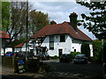
The Garsdale
Country inn and restaurant near Bury.
Image: © John H Darch
Taken: 15 May 2010
0.21 miles