IMAGES TAKEN NEAR TO
Buckley Street, BURY, BL9 5AF
Introduction
This page details the photographs taken nearby to Buckley Street, BL9 5AF by members of the Geograph project.
The Geograph project started in 2005 with the aim of publishing, organising and preserving representative images for every square kilometre of Great Britain, Ireland and the Isle of Man.

There are currently over 7.5m images from over14,400 individuals and you can help contribute to the project by visiting https://www.geograph.org.uk
Image Map
Images are licensed for reuse under creativecommons.org/licenses/by-sa/2.0
Notes
- Clicking on the map will re-center to the selected point.
- The higher the marker number, the further away the image location is from the centre of the postcode.
Image Listing (171 Images Found)
Images are licensed for reuse under creativecommons.org/licenses/by-sa/2.0
Image
Details
Distance
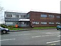
1
Freedom Church
Walmersley Road, Bury.
Image: © Gerald England
Taken: 19 Jan 2019
0.08 miles
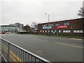
2
Evolve Military College
The college on Walmersley Road occupies a building formerly used by Freedom Church Image
It is one of four similar colleges. The others are in Burnley, Wigan and Blackpool.
Image: © Gerald England
Taken: 12 Dec 2020
0.09 miles
3
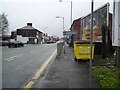
Walmersley Road
The A56 out of Bury.
Image: © Gerald England
Taken: 12 Dec 2020
0.09 miles
4
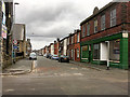
Hornby Street Bury
Looking north (away from the town centre) along Hornby Street.
Image: © David Dixon
Taken: 23 Mar 2018
0.09 miles
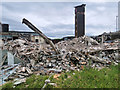
9
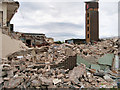
Demolition of Bury Fire Station June 2020
Image: © David Dixon
Taken: 22 Jun 2020
0.11 miles
10
Demolition of Old Fire Station - June 2020
Image: © David Dixon
Taken: 30 Jun 2020
0.11 miles