IMAGES TAKEN NEAR TO
Dunster Road, BURY, BL9 0RD
Introduction
This page details the photographs taken nearby to Dunster Road, BL9 0RD by members of the Geograph project.
The Geograph project started in 2005 with the aim of publishing, organising and preserving representative images for every square kilometre of Great Britain, Ireland and the Isle of Man.

There are currently over 7.5m images from over14,400 individuals and you can help contribute to the project by visiting https://www.geograph.org.uk
Image Map
Images are licensed for reuse under creativecommons.org/licenses/by-sa/2.0
Notes
- Clicking on the map will re-center to the selected point.
- The higher the marker number, the further away the image location is from the centre of the postcode.
Image Listing (548 Images Found)
Images are licensed for reuse under creativecommons.org/licenses/by-sa/2.0
Image
Details
Distance
1
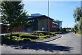
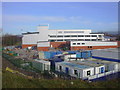
Bury Police HQ
Relocated from a former site on Castle Street. The wall on the right is north-facing so wouldn't often catch any sun.
Image: © Bill Boaden
Taken: 29 Aug 2016
0.02 miles
3
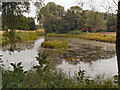
Pond
The pond on the newly developed area between the Police HQ and the new fire station in Bury. The pond was an existing feature, not artificially created during the landscaping.
Image: © David Dixon
Taken: 7 Sep 2012
0.06 miles
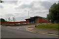
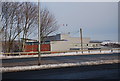
4
Development Site Access Road
Not open yet to the public
Image: © Robert Wade
Taken: 31 Jan 2010
0.07 miles
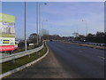
5
Bury's new ?20 million divisional police headquarters under construction which is due to open in the Spring of 2010
Image: © Robert Wade
Taken: 31 Jan 2010
0.08 miles
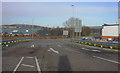
6
Bury's New Police Station
The old police station was in Irwell St. Image
Image: © N Chadwick
Taken: 18 Dec 2010
0.08 miles
7
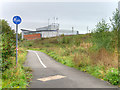
Footpath and Cycleway near the Police Station
Part of National Cycle Network Route 6.
Image: © David Dixon
Taken: 28 Sep 2016
0.08 miles
9
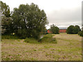
Landscaped Area
The landscaped area between the new police HQ on Dunster Road and the new fire station on Magdalene Road. The land is bounded on the other two sides by Castlecroft Road and Harvard Road.
Image: © David Dixon
Taken: 7 Sep 2012
0.11 miles
10
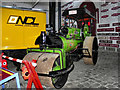
Bury Transport Museum, Steam Roller "Hilda"
Hilda is one of the exhibits at the restored goods warehouse at Castlecroft (Image]).
Built in 1921, Hilda was in service until 1971 with the building firm R & T Howarth Ltd of Deeplish. Steam rollers were used for levelling surfaces such as roads.
Image: © David Dixon
Taken: 30 Nov 2011
0.11 miles