IMAGES TAKEN NEAR TO
Larkfield Close, BURY, BL8 4QJ
Introduction
This page details the photographs taken nearby to Larkfield Close, BL8 4QJ by members of the Geograph project.
The Geograph project started in 2005 with the aim of publishing, organising and preserving representative images for every square kilometre of Great Britain, Ireland and the Isle of Man.

There are currently over 7.5m images from over14,400 individuals and you can help contribute to the project by visiting https://www.geograph.org.uk
Image Map
Images are licensed for reuse under creativecommons.org/licenses/by-sa/2.0
Notes
- Clicking on the map will re-center to the selected point.
- The higher the marker number, the further away the image location is from the centre of the postcode.
Image Listing (15 Images Found)
Images are licensed for reuse under creativecommons.org/licenses/by-sa/2.0
Image
Details
Distance
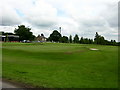
3
Greenmount Golf Club
The valley carries a tributary of Kirklees Brook
Image: © Bill Boaden
Taken: 25 Oct 2020
0.13 miles
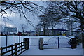
4
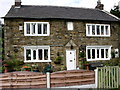
House on Greenmount Golf Course
This house is accessed from the Golf Course.
Built 1744
Image: © liz dawson
Taken: 16 Jun 2007
0.13 miles
5
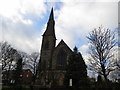
Greenmount United Reformed Church
Greenmount is a suburb of Bury.
Image: © philandju
Taken: 2 Jan 2014
0.14 miles
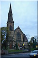
6
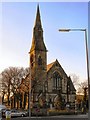
Greenmount United Reformed Church
The nineteenth century Church, with its distinctive spire and in its prominent position, was and still is the focal point of the village. The first service in the Green Mount Congregational (now Greenmount United Reformed) Church, was held on Sunday 24th February 1867 (http://www.greenmountvillage.org.uk/index_files/church_history.htm Green Mount Congregational Church: A Brief History). It is a grade II listed building (Historic England List Entry Number: 1163452 http://www.heritagegateway.org.uk/Gateway/Results_Single.aspx?uid=1163452&resourceID=5 Heritage Gateway).
Image: © David Dixon
Taken: 8 Mar 2010
0.15 miles
7
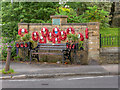
Greenmount Village War Memorial
The War Memorial is on the wall outside Greenmount United Reformed Church.
Image: © David Dixon
Taken: 27 Jun 2016
0.17 miles
8
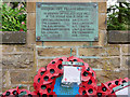
Greenmount Village Memorial World War II Plaque
Plaque affixed to Image] lists the names and rank of those who died during World War Two.
Image: © David Dixon
Taken: 27 Jun 2016
0.17 miles
9
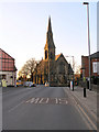
Brandlesholme Road and URC, Greenmount
Looking along Brandlesholme Road to Greenmount United Reformed Church on Holcombe Road.
The nineteenth century Church, with its distinctive spire and in its prominent position, was and still is the focal point of the village. The first service in the Green Mount Congregational (now Greenmount United Reformed) Church, was held on Sunday 24th February 1867 (http://www.greenmountvillage.org.uk/index_files/church_history.htm Green Mount Congregational Church: A Brief History). It is a grade II listed building (Historic England List Entry Number: 1163452 http://www.heritagegateway.org.uk/Gateway/Results_Single.aspx?uid=1163452&resourceID=5 Heritage Gateway).
Image: © David Dixon
Taken: 8 Mar 2010
0.17 miles