1
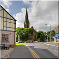
Greenmount United Reformed Church
Greenmount is a suburb of Bury.
Image: © philandju
Taken: 2 Jan 2014
0.16 miles
2
Brookhouse Farm Birth place of Henry Wood
Henry Wood, a Quaker from the Bury in the North-West of England, left Great Britain due to religious persecution.
He was incarcerated in Lancaster gaol for practising as a Quaker but when he was released he left his home in the village of Tottington, near Bury, and sailed to America with his family on the ship 'Lyon' to set up a community in the new world where he and his family could practice his religion freely.
His surname and his home town went to make up the name of the City he founded - Woodbury in the United States of America.
By 1715 Woodbury had become a Quaker religious centre and was a thriving hamlet at the onset of the American Revolution.
In 2000, the Borough of Bury, England, and the City of Woodbury were twinned as part of millennium celebrations in both countries.
Image
Image: © Paul Anderson
Taken: 23 Mar 2007
0.16 miles
3
Henry Wood Millennium Plaque
Image: © Paul Anderson
Taken: 23 Mar 2007
0.16 miles
4
Greenmount Village Memorial World War II Plaque
Plaque affixed to
Image] lists the names and rank of those who died during World War Two.
Image: © David Dixon
Taken: 27 Jun 2016
0.16 miles
5
Greenmount Village War Memorial
The War Memorial is on the wall outside Greenmount United Reformed Church.
Image: © David Dixon
Taken: 27 Jun 2016
0.16 miles
6
Greenmount Village
Historically a part of Lancashire, but now part of the Metropolitan Borough of Bury, within Greater Manchester, Greenmount is 13 miles north of Manchester, 1 mile to the northeast of Tottington, and 2 miles to the south of Ramsbottom. The name Greenmount only came into existence in 1848 when the Sunday School was built. It was originally spelt Green Mount. At that time, Greenmount was, part of the outskirts of the village of Tottington. At first, people who lived near to the Sunday School included the name of Greenmount in their address and gradually this was extended to the surrounding area and so Greenmount became a village.
The nineteenth century Church, with its distinctive spire and in its prominent position, was and still is the focal point of the village. The first service in the Green Mount Congregational (now Greenmount United Reformed) Church, was held on Sunday 24th February 1867 (http://www.greenmountvillage.org.uk/index_files/church_history.htm Green Mount Congregational Church: A Brief History). It is a grade II listed building (Historic England List Entry Number: 1163452 http://www.heritagegateway.org.uk/Gateway/Results_Single.aspx?uid=1163452&resourceID=5 Heritage Gateway).
The village of Greenmount now has its own community web page http://www.greenmountvillage.org.uk/ .
Image: © David Dixon
Taken: 27 Jun 2016
0.16 miles
7
Greenmount United Reformed Church
The nineteenth century Church, with its distinctive spire and in its prominent position, was and still is the focal point of the village. The first service in the Green Mount Congregational (now Greenmount United Reformed) Church, was held on Sunday 24th February 1867 (http://www.greenmountvillage.org.uk/index_files/church_history.htm Green Mount Congregational Church: A Brief History). It is a grade II listed building (Historic England List Entry Number: 1163452 http://www.heritagegateway.org.uk/Gateway/Results_Single.aspx?uid=1163452&resourceID=5 Heritage Gateway).
Image: © David Dixon
Taken: 8 Mar 2010
0.17 miles
8
Brandlesholme Road and URC, Greenmount
Looking along Brandlesholme Road to Greenmount United Reformed Church on Holcombe Road.
The nineteenth century Church, with its distinctive spire and in its prominent position, was and still is the focal point of the village. The first service in the Green Mount Congregational (now Greenmount United Reformed) Church, was held on Sunday 24th February 1867 (http://www.greenmountvillage.org.uk/index_files/church_history.htm Green Mount Congregational Church: A Brief History). It is a grade II listed building (Historic England List Entry Number: 1163452 http://www.heritagegateway.org.uk/Gateway/Results_Single.aspx?uid=1163452&resourceID=5 Heritage Gateway).
Image: © David Dixon
Taken: 8 Mar 2010
0.17 miles
9
Toby Carvery at Bulls Head
Newly refurbished Bulls Head in Greenmount
Image: © liz dawson
Taken: 16 Jun 2007
0.17 miles
10
Greenmount
This is the centre of Greenmount at the junction of Holcombe Road and Brandlesholme Road'
The newly refurbished Bulls Head pub is on the corner.
Greenmounts most notable residents are the Manchester United team-mates and brothers Gary and Phil Neville who were both born and raised in the village, the Neville brothers also played cricket at Greenmount Cricket club and were both junior members of Greenmount golf club.
TV presenter (and former Emmerdale actor) Lisa Riley was also born and raised in Greenmount.
Image: © Paul Anderson
Taken: 23 Mar 2007
0.17 miles


