IMAGES TAKEN NEAR TO
Moor Road, BURY, BL8 4NT
Introduction
This page details the photographs taken nearby to Moor Road, BL8 4NT by members of the Geograph project.
The Geograph project started in 2005 with the aim of publishing, organising and preserving representative images for every square kilometre of Great Britain, Ireland and the Isle of Man.

There are currently over 7.5m images from over14,400 individuals and you can help contribute to the project by visiting https://www.geograph.org.uk
Image Map
Images are licensed for reuse under creativecommons.org/licenses/by-sa/2.0
Notes
- Clicking on the map will re-center to the selected point.
- The higher the marker number, the further away the image location is from the centre of the postcode.
Image Listing (37 Images Found)
Images are licensed for reuse under creativecommons.org/licenses/by-sa/2.0
Image
Details
Distance
2
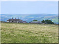
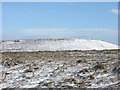
Harcles Hill Farm
A moorland farm on the top of Holcombe Moor just below Harcles Hill which rises to the right. Manchester can be seen in the distance.
Image: © Bill Boaden
Taken: 14 May 2020
0.03 miles
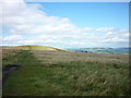
3
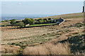
From Harcles to Scout and Knowl Moors
Taken from the top of Harcles Hill and looking east towards Scout Moor and Knowl Moor beyond that.
Image: © Carroll Pierce
Taken: 25 Nov 2013
0.10 miles
4
Harcles Hill near Ramsbottom
Looking north this is Harcles Hill with Harcles Hill Farm on the far right.
Image: © Paul Anderson
Taken: 25 May 2007
0.11 miles
6
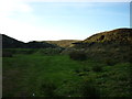
Quarry and clough
The clough dividing the hills of Holcombe and Harcles being too boggy for this particular walker, I was directed by a kind local to an alternative route to the base of Harcles via this long-disused quarry, located where the path from the Peel Monument turns into Moor Road on its way down into the village. The stream still requires a little negotiation but I found it to be much less worrisome than the stretch further up and there is at least that wall to cling to!
Image: © Carroll Pierce
Taken: 25 Nov 2013
0.12 miles
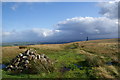
7
Harcles Hill
Taken from the edge of Holcombe Moor near the Peel Monument, above Ramsbottom, Lancashire. Rossendale is visible beyond the hill with Pendle Hill just discernible in centre horizon.
Image: © Carroll Pierce
Taken: 16 Aug 2013
0.13 miles
8
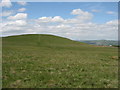
The top of Harcles Hill
This is slightly more off the beaten track than the area around Peel Tower. The eye is naturally drawn to the surrounding views in all directions apart from the north west
Image: © Bill Boaden
Taken: 4 Sep 2009
0.13 miles
9
Harcles to Manchester
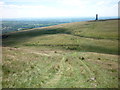
Atop Harcles Hill, Lancashire, I am looking beyond the Peel Monument to the centre of Manchester in the hazy distance. If you look very carefully just to the left of the monument, you will see the strikingly tall Beetham Tower at the end of Deansgate.
Image: © Carroll Pierce
Taken: 10 Jul 2014
0.13 miles
10
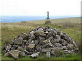
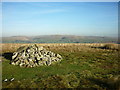
Harcles Hill, Cairn
Cairn, marking the summit of Harcles Hill.
Image: © David Dixon
Taken: 15 Aug 2010
0.14 miles