IMAGES TAKEN NEAR TO
Holcombe Old Road, BURY, BL8 4NF
Introduction
This page details the photographs taken nearby to Holcombe Old Road, BL8 4NF by members of the Geograph project.
The Geograph project started in 2005 with the aim of publishing, organising and preserving representative images for every square kilometre of Great Britain, Ireland and the Isle of Man.

There are currently over 7.5m images from over14,400 individuals and you can help contribute to the project by visiting https://www.geograph.org.uk
Image Map
Images are licensed for reuse under creativecommons.org/licenses/by-sa/2.0
Notes
- Clicking on the map will re-center to the selected point.
- The higher the marker number, the further away the image location is from the centre of the postcode.
Image Listing (60 Images Found)
Images are licensed for reuse under creativecommons.org/licenses/by-sa/2.0
Image
Details
Distance
1
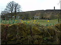
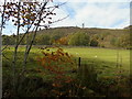
Hill End Farm
Taken on Holcombe Old Road, Holcombe, Greater Manchester, I am looking across Hill End Farm to Holcombe Hill and the Peel Monument.
Image: © Carroll Pierce
Taken: 6 Apr 2018
0.02 miles
2
Holcombe Hill
Taken from Lumb Carr Road, Holcombe Brook, Lancashire.
Image: © Carroll Pierce
Taken: 16 Aug 2013
0.04 miles
3
Nuttall, Ramsbottom
This is Nuttall, Ramsbottom, Greater Manchester, with Nangreaves in the middle distance across the M66, as seen from the Peel Monument above Holcombe. Rochdale extends across the horizon beyond the hills.
Image: © Carroll Pierce
Taken: 29 Dec 2015
0.07 miles
4
East Lancashire Railway
Taken on Lumb Carr Road, I was alerted by its whistle to the presence of the steam train on the section of the East Lancashire Railway between Summerseat and Ramsbottom. Holcombe, Greater Manchester.
Image: © Carroll Pierce
Taken: 19 Oct 2018
0.07 miles
5
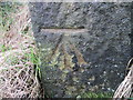
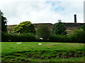
Ordnance Survey Cut Mark
This mark can be found on a stone post in Lumb Carr Road, Hazelhurst.
Image: © Peter Wood
Taken: 25 Jan 2012
0.09 miles
6
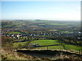
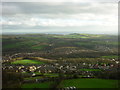
From the Millennium bench to Oldham
Just below the Peel Monument on the south-eastern edge of Holcombe Moor, there is a bench which commands panoramic views of Greater Manchester and Rossendale. This shot is looking across Brooksbottoms and Summerseat towards Oldham.
Image: © Carroll Pierce
Taken: 25 Nov 2013
0.10 miles
7
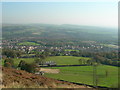
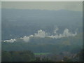
View East-southeast from Hill End
View down over Hill End Farm and across Hazelhurst – Ramsbottom.
Image: © John Topping
Taken: 29 Sep 2011
0.10 miles
8
Hill End Farm to Holcombe
Taken on Moorbottom Road on the eastern flank of Holcombe Moor, I am looking down to Holcombe village, marked out by the tip of the spire of Emmanuel Church to the left. Cowpe Lowe and the northern edge of Scout Moor wind farm lie along the horizon.
Image: © Carroll Pierce
Taken: 29 Dec 2015
0.10 miles
9
The hill at Holcombe
Taken on Holcombe Old Road, Holcombe, near Ramsbottom, Greater Manchester, I am look up at my destination, the Peel Monument atop Holcombe Hill. The fields of Hill End Farm lie between me and the upward path.
Image: © Carroll Pierce
Taken: 19 Oct 2018
0.10 miles
10
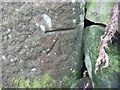
Ordnance Survey Cut Mark
This can be found on a stone post in the wall alongside Lumb Carr Road, Holcombe.
Image: © Peter Wood
Taken: 25 Jan 2012
0.10 miles