IMAGES TAKEN NEAR TO
Hollymount Lane, BURY, BL8 4HS
Introduction
This page details the photographs taken nearby to Hollymount Lane, BL8 4HS by members of the Geograph project.
The Geograph project started in 2005 with the aim of publishing, organising and preserving representative images for every square kilometre of Great Britain, Ireland and the Isle of Man.

There are currently over 7.5m images from over14,400 individuals and you can help contribute to the project by visiting https://www.geograph.org.uk
Image Map (Loading...)


Getting Data...Please wait
Leaflet Map data © OpenStreetMap
Images are licensed for reuse under creativecommons.org/licenses/by-sa/2.0
Notes
- Clicking on the map will re-center to the selected point.
- The higher the marker number, the further away the image location is from the centre of the postcode.
Image Listing (10 Images Found)
Images are licensed for reuse under creativecommons.org/licenses/by-sa/2.0
Image
Details
Distance
1
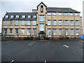
Hollymount Primary School
Hollymount primary school is located at the top of a hill accessed via a long lane (Hollymount Lane). Hollymount school is an extremely large, impressive building with a strong catholic heritage, the school's former headmistress (Sister James) was one of several nuns teaching at the school right up until the early 1990s. Adjacent to Hollymount school used to be a convent with splendid gardens and a grotto of Lady Mary, children would form a procession of prayer here on May day each year.
Sadly, however, the convent closed in the late '80s and much of the convent has now been knocked down and replaced with modern houses.
School pupils flourish at Hollymount.
Image: © Paul Anderson
Taken: 21 Jan 2007
0.05 miles
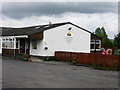
2
Hollymount housing
Next to Hollymount RC School.
Previously a convent/children's home.
Image: © liz dawson
Taken: 16 Jun 2007
0.06 miles
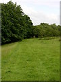
4
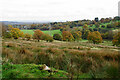
Two Brooks Valley
It drains into Kirklees Brook which meets the Irwell near Bury. Oldham can be seen in the distance.
Image: © Bill Boaden
Taken: 25 Oct 2020
0.11 miles
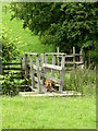
5
Soggy path near Holly Mount
The state of the path gets a bit worse as it descends into Two Brooks Valley.
Image: © Bill Boaden
Taken: 25 Oct 2020
0.13 miles
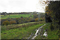
9
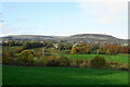
Two Brooks Valley
In the background is Holcombe Moor, with the highest point, Bull Hill, at the back and centre.
Image: © Bill Boaden
Taken: 25 Oct 2020
0.23 miles
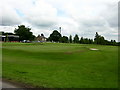
10
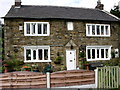
House on Greenmount Golf Course
This house is accessed from the Golf Course.
Built 1744
Image: © liz dawson
Taken: 16 Jun 2007
0.25 miles