IMAGES TAKEN NEAR TO
Peel Cottages, BURY, BL8 3QN
Introduction
This page details the photographs taken nearby to Peel Cottages, BL8 3QN by members of the Geograph project.
The Geograph project started in 2005 with the aim of publishing, organising and preserving representative images for every square kilometre of Great Britain, Ireland and the Isle of Man.

There are currently over 7.5m images from over14,400 individuals and you can help contribute to the project by visiting https://www.geograph.org.uk
Image Map (Loading...)


Getting Data...Please wait
Leaflet Map data © OpenStreetMap
Images are licensed for reuse under creativecommons.org/licenses/by-sa/2.0
Notes
- Clicking on the map will re-center to the selected point.
- The higher the marker number, the further away the image location is from the centre of the postcode.
Image Listing (66 Images Found)
Images are licensed for reuse under creativecommons.org/licenses/by-sa/2.0
Image
Details
Distance
1
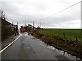
The number 480 entering Affetside
Perhaps surprisingly, Affetside village still enjoys a bus service.
Image: © philandju
Taken: 13 Jan 2014
0.02 miles
2
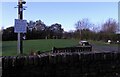
Don't miss the fun
Affetside's annual bonfire night celebration advertised on the village green.
Image: © philandju
Taken: 3 Nov 2022
0.03 miles
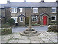
3
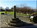
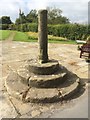
Affetside Cross
The restored cross is said to be a waymarker on the Roman road from Manchester to Ribchester.
Image: © philandju
Taken: 20 Jan 2017
0.04 miles
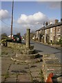
5
Affetside Cross, Watling Street
The cross at Affetside is a listed grade II structure, believed by many to be of Roman origin (possibly because of its proximity to the Roman road), supposedly marking the mid point between London and Edinburgh. English heritage, however suggest that its origins may be much later, perhaps 17th or 18th century. http://www.pastscape.org.uk/hob.aspx?hob_id=44366&sort=4&search=all&criteria=affetside&rational=q&recordsperpage=10 . Present thinking (http://en.wikipedia.org/wiki/Affetside ) considers it as a mediæval route marker for Lancashire pilgrims on route to Whalley Abbey.
The cross marks the route of the Roman road from Manchester to Ribchester, also known as Watling Street. The stone shaft has a socket cut into the top which originally supported a cross head or stone ball. The structure would have served as a market cross for Affetside and surrounding hamlets and possibly as a place for preaching and public proclamations. This form of standing cross would have been relatively common in mediæval settlements. However they were largely swept away in the upheavals of the Reformation during the mid 16th and 17th centuries, making Affetside’s cross a relatively rare survival.
Affetside Cross is designated as a scheduled Ancient Monument under the provisions of the Ancient Monuments and Archaeological Areas Act of 1979 (National Monument 25721).
Image] shows a picture of the cross taken in 1976.
There is an interesting account of the history of Affetside and its cross on the wikipedia page http://en.wikipedia.org/wiki/Affetside
Image: © David Dixon
Taken: 14 Jul 2011
0.07 miles
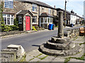
6
Affetside, cross
A plaque states this to be the shaft of a Roman cross or pillar, but English Heritage dates it much later. http://www.pastscape.org.uk/SearchResults.aspx?rational=q&criteria=affetside&search=ALL&sort=4&recordsperpage=10
Image: © Mike Faherty
Taken: 19 Oct 2009
0.07 miles
7
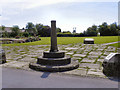
Affetside Cross and Millennium Green
A listed grade II structure, believed by many to be of Roman origin (possibly because of its proximity to the Roman road), supposedly marking the mid point between London and Edinburgh. English heritage, however suggest that its origins may be much later, perhaps 17th or 18th century. http://www.pastscape.org.uk/hob.aspx?hob_id=44366&sort=4&search=all&criteria=affetside&rational=q&recordsperpage=10 . Present thinking (http://en.wikipedia.org/wiki/Affetside ) considers it as a mediæval route marker for Lancashire pilgrims on route to Whalley Abbey.
The cross marks the route of the Roman road from Manchester to Ribchester, also known as Watling Street. The stone shaft has a socket cut into the top which originally supported a cross head or stone ball. The structure would have served as a market cross for Affetside and surrounding hamlets and possibly as a place for preaching and public proclamations. This form of standing cross would have been relatively common in mediæval settlements. However they were largely swept away in the upheavals of the Reformation during the mid 16th and 17th centuries, making Affetside’s cross a relatively rare survival.
Affetside Cross is designated as a scheduled Ancient Monument under the provisions of the Ancient Monuments and Archaeological Areas Act of 1979 (National Monument 25721).
The Millennium Green was created on the site of a redundant bus turnaround which had been disused for a number of years. (see Image] for further information). Image] shows a picture of the cross before the Millennium Green was constructed.
There is an interesting account of the history of Affetside and its cross on the wikipedia page http://en.wikipedia.org/wiki/Affetside
Image: © David Dixon
Taken: 14 Jul 2011
0.07 miles
8
Old Wayside Cross by Watling Street, Affetside, Bolton parish
Affetside Cross, old shaft, base and steps, by the wayside, in parish of Bolton (Bolton District), Watling Street, South Turton, way point between London and Edinburgh. A medieval route marker for Lancashire pilgrims on route to Whalley Abbey.
Grade II listed.
List Entry Number: 1162874 https://historicengland.org.uk/listing/the-list/list-entry/1162874
Scheduled Monument.
List Entry Number: 1014120 https://historicengland.org.uk/listing/the-list/list-entry/1014120
To be surveyed
Milestone Society National ID: MABO_BOL01
Image: © Milestone Society
Taken: Unknown
0.07 miles
9
Affetside Bolton
The cross on the Roman Watling Street outside the old Pack Horse Inn where the skull of Mr Whowell who took part in the execution of Lord Derby during the English civil war is kept behind the bar.
Image: © frances barton
Taken: 30 Jul 2003
0.07 miles