IMAGES TAKEN NEAR TO
Watling Street, BURY, BL8 3QJ
Introduction
This page details the photographs taken nearby to Watling Street, BL8 3QJ by members of the Geograph project.
The Geograph project started in 2005 with the aim of publishing, organising and preserving representative images for every square kilometre of Great Britain, Ireland and the Isle of Man.

There are currently over 7.5m images from over14,400 individuals and you can help contribute to the project by visiting https://www.geograph.org.uk
Image Map
Images are licensed for reuse under creativecommons.org/licenses/by-sa/2.0
Notes
- Clicking on the map will re-center to the selected point.
- The higher the marker number, the further away the image location is from the centre of the postcode.
Image Listing (9 Images Found)
Images are licensed for reuse under creativecommons.org/licenses/by-sa/2.0
Image
Details
Distance
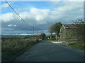
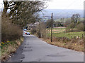
1
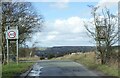
Watling Street near Affetside
Unless remedial pruning is carried out the roadside speed sign on the right will soon be obscured by new leaves. The same fate seems likely for the left hand sign a little later in the year.
Image: © philandju
Taken: 24 Mar 2023
0.01 miles
3
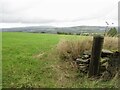
Field, Affetside
View towards Winter Hill.
Image: © Richard Webb
Taken: 6 Sep 2022
0.06 miles
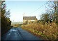
4
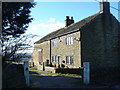
Bradshaw Head farm
On the course of Watling Street, the Roman road.
Image: © Margaret Clough
Taken: 9 Feb 2006
0.11 miles
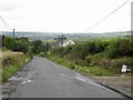
8
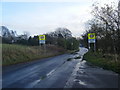
Watling Street, Affetside.
Looking south as the Roman road goes up to Affetside, believed to be the mid point between London and Edinburgh (by an indirect route?)
Image: © Colin Pyle
Taken: 11 Nov 2009
0.20 miles
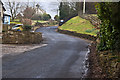
9
Watling Street
The Roman road, at Bradshaw Head
Image: © David Dixon
Taken: 10 Apr 2010
0.24 miles