IMAGES TAKEN NEAR TO
Kirklees Street, BURY, BL8 3NJ
Introduction
This page details the photographs taken nearby to Kirklees Street, BL8 3NJ by members of the Geograph project.
The Geograph project started in 2005 with the aim of publishing, organising and preserving representative images for every square kilometre of Great Britain, Ireland and the Isle of Man.

There are currently over 7.5m images from over14,400 individuals and you can help contribute to the project by visiting https://www.geograph.org.uk
Image Map (Loading...)


Getting Data...Please wait
Leaflet Map data © OpenStreetMap
Images are licensed for reuse under creativecommons.org/licenses/by-sa/2.0
Notes
- Clicking on the map will re-center to the selected point.
- The higher the marker number, the further away the image location is from the centre of the postcode.
Image Listing (54 Images Found)
Images are licensed for reuse under creativecommons.org/licenses/by-sa/2.0
Image
Details
Distance
2
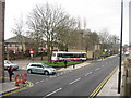
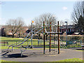
Tottington Bus Terminus
Situated at the bottom end of Market Street across the road from Image is the Bus Terminus for Tottington village.
Image: © Paul Anderson
Taken: 23 Mar 2007
0.06 miles
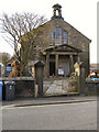
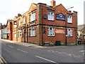
3
Hark To Towler
Market Street, Tottington.
Image: © David Dixon
Taken: 8 Apr 2010
0.07 miles
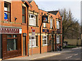
4
Hark To Towler
The junction of Kirklees Street and Market Street, Tottington.
Image: © David Dixon
Taken: 8 Apr 2010
0.07 miles
5
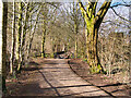
Kirklees Trail (The Lines), Tottington
The Bury–Holcombe Brook line was a 3¾-mile (6km) single-track railway line which ran between Bury Bolton Street railway station and Holcombe Brook railway station via seven intermediate stations. The section of the line from Greenmount to Bury town centre has been converted into a pedestrian and cycle route, the Kirklees Trail (also known as “the Lines”), forming part of National Cycle Route 6.
Image: © David Dixon
Taken: 16 Mar 2021
0.07 miles
7
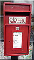
Close up, Elizabeth II postbox on Market Street, Tottington
Outside the Post Office.
Postbox No. BL8 45.
See Image] for wider view.
Image: © JThomas
Taken: 17 Sep 2018
0.08 miles
8
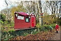
Tottington Station
The Bury–Holcombe Brook line was a 3¾-mile (6km) single-track railway line which ran between Bury Bolton Street railway station and Holcombe Brook railway station via seven intermediate stations. The line opened in 1882 but the closure of the local mills during the first half of the twentieth century led to a fall in passenger numbers. The last passenger train ran on 4 May 1951; freight trains continued to run until 17 Augur 1963. The section of the line from Greenmount to Bury town centre has been converted into a pedestrian and cycle route, the Kirklees Trail (also known as “the Lines”), forming part of National Cycle Route 6.
Tottington station closed when passenger services were withdrawn in 1952 and it was demolished; very little remains of it. This representation of the station was erected in July 2021 as part of the Tottington Scarecrow Festival.
Image: © David Dixon
Taken: 25 Nov 2021
0.08 miles
9
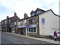
Post Office and shops on Market Street, Tottington
Showing position of Postbox No. BL8 45.
See Image] for postbox.
Image: © JThomas
Taken: 17 Sep 2018
0.08 miles
10
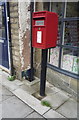
Elizabeth II postbox on Market Street, Tottington
Image: © JThomas
Taken: 17 Sep 2018
0.08 miles