IMAGES TAKEN NEAR TO
Sunnywood Close, BURY, BL8 3GH
Introduction
This page details the photographs taken nearby to Sunnywood Close, BL8 3GH by members of the Geograph project.
The Geograph project started in 2005 with the aim of publishing, organising and preserving representative images for every square kilometre of Great Britain, Ireland and the Isle of Man.

There are currently over 7.5m images from over14,400 individuals and you can help contribute to the project by visiting https://www.geograph.org.uk
Image Map
Images are licensed for reuse under creativecommons.org/licenses/by-sa/2.0
Notes
- Clicking on the map will re-center to the selected point.
- The higher the marker number, the further away the image location is from the centre of the postcode.
Image Listing (8 Images Found)
Images are licensed for reuse under creativecommons.org/licenses/by-sa/2.0
Image
Details
Distance
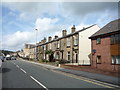
2
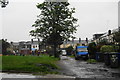
Stone terraced houses with gardens, Tottington
Victorian terraces typical of this area.
Image: © Margaret Clough
Taken: 23 Feb 2006
0.07 miles
3
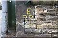
WWII Lancashire: Ghost Signs of the Home Front (18)
-
Emergency Rendezvous Point, Bury Road, Tottington, Bury, at junction with Rhode Street
"ERP 275"
Emergency Rendezvous Points (ERP) were designated places in the locality for the coordination of ARP and emergency services during civil emergencies, particularly for those services arriving from outside the area. The signs appear in a variety of designs, but most are diamond shapes framing the ERP locality number.
Image
Image: © Mike Searle
Taken: 13 Aug 2021
0.07 miles
4
WWII Lancashire: Ghost Signs of the Home Front (19)
-
Emergency Rendezvous Point, Bury Road, Tottington, Bury, at junction with Rhode Street
"ERP 275"
Emergency Rendezvous Points (ERP) were designated places in the locality for the coordination of ARP and emergency services during civil emergencies, particularly for those services arriving from outside the area. The signs appear in a variety of designs, but most are diamond shapes framing the ERP locality number.
Image
Image: © Mike Searle
Taken: 13 Aug 2021
0.07 miles
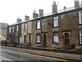
5
Back passage for Holly Street
This is a wide one compared with most. It backs onto an area of open green space which is managed by the Council.
Image: © Bill Boaden
Taken: 19 Sep 2010
0.14 miles
6
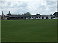
Walshaw Cricket Club - Pavilion
The pavilion (left) and changing rooms (right) at Walshaw CC's Sycamore Road ground. The changing rooms are named after "Bob Pilkington".
Image: © BatAndBall
Taken: 10 Jun 2012
0.18 miles
7
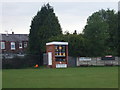
Walshaw Cricket Club - Scoreboard
Walshaw CC's scoreboard and nets.
The club have two teams in the Bolton & District Cricket Association and a third in the North Manchester Cricket League.
Image: © BatAndBall
Taken: 10 Jun 2012
0.19 miles
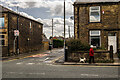
8
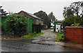
The entrance to Booth Farm
Tottington has grown up around this farm, but it is still operating.
Image: © Bill Boaden
Taken: 19 Sep 2010
0.22 miles