IMAGES TAKEN NEAR TO
Scobell Street, BURY, BL8 3DP
Introduction
This page details the photographs taken nearby to Scobell Street, BL8 3DP by members of the Geograph project.
The Geograph project started in 2005 with the aim of publishing, organising and preserving representative images for every square kilometre of Great Britain, Ireland and the Isle of Man.

There are currently over 7.5m images from over14,400 individuals and you can help contribute to the project by visiting https://www.geograph.org.uk
Image Map
Images are licensed for reuse under creativecommons.org/licenses/by-sa/2.0
Notes
- Clicking on the map will re-center to the selected point.
- The higher the marker number, the further away the image location is from the centre of the postcode.
Image Listing (13 Images Found)
Images are licensed for reuse under creativecommons.org/licenses/by-sa/2.0
Image
Details
Distance
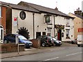
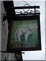
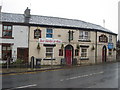
3
The Lamb public House, Woolfold
On Tottington Road.
Image: © JThomas
Taken: 17 Sep 2018
0.06 miles
5
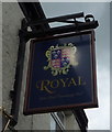
Sign for the Royal public house, Tottington
Image: © JThomas
Taken: 17 Sep 2018
0.06 miles
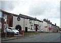
7
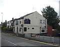
The Royal public house, Tottington
On Bury Road.
Image: © JThomas
Taken: 17 Sep 2018
0.06 miles
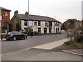
8
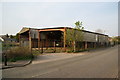
Vacant industrial premises on Scobell Street
These premises are up for sale, with planning permission for residential development. It is a quiet road which could accommodate more houses.
Image: © Bill Boaden
Taken: 20 Apr 2011
0.07 miles
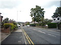
10
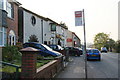
Bus stop by the Lamb Inn
This is on Bury Road Tottington, and the Lamb Inn is the official name for this stop.
Image: © Bill Boaden
Taken: 20 Apr 2011
0.09 miles