IMAGES TAKEN NEAR TO
Neston Road, BURY, BL8 3DB
Introduction
This page details the photographs taken nearby to Neston Road, BL8 3DB by members of the Geograph project.
The Geograph project started in 2005 with the aim of publishing, organising and preserving representative images for every square kilometre of Great Britain, Ireland and the Isle of Man.

There are currently over 7.5m images from over14,400 individuals and you can help contribute to the project by visiting https://www.geograph.org.uk
Image Map
Images are licensed for reuse under creativecommons.org/licenses/by-sa/2.0
Notes
- Clicking on the map will re-center to the selected point.
- The higher the marker number, the further away the image location is from the centre of the postcode.
Image Listing (31 Images Found)
Images are licensed for reuse under creativecommons.org/licenses/by-sa/2.0
Image
Details
Distance
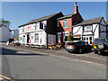
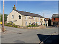
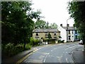
2
Hall Street, Walshaw
With the White Horse
Image: © Richard Webb
Taken: 6 Sep 2022
0.11 miles
3
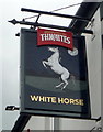
Sign for the White Horse public house, Walshaw
Image: © JThomas
Taken: 10 Sep 2018
0.12 miles
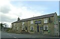
4
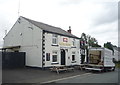
The White Horse public house, Walshaw
On Hall Street.
Image: © JThomas
Taken: 10 Sep 2018
0.12 miles
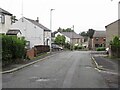
7
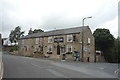
The Victoria public house, Walshaw
On Hall Street.
Image: © JThomas
Taken: 10 Sep 2018
0.14 miles
8
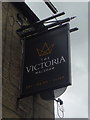
Sign for the Victoria public house, Walshaw
Image: © JThomas
Taken: 10 Sep 2018
0.14 miles
9
Church Street becomes Bank Street
The road name changes at this bend. The three stone cottages are Bank Terrace.
Image: © philandju
Taken: 17 Aug 2017
0.14 miles
10
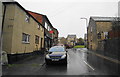
Bank Street, Walshaw
It is about to join High Street.
Image: © Bill Boaden
Taken: 19 Sep 2010
0.15 miles