IMAGES TAKEN NEAR TO
Brookthorpe Road, BURY, BL8 3AD
Introduction
This page details the photographs taken nearby to Brookthorpe Road, BL8 3AD by members of the Geograph project.
The Geograph project started in 2005 with the aim of publishing, organising and preserving representative images for every square kilometre of Great Britain, Ireland and the Isle of Man.

There are currently over 7.5m images from over14,400 individuals and you can help contribute to the project by visiting https://www.geograph.org.uk
Image Map (Loading...)


Getting Data...Please wait
Leaflet Map data © OpenStreetMap
Images are licensed for reuse under creativecommons.org/licenses/by-sa/2.0
Notes
- Clicking on the map will re-center to the selected point.
- The higher the marker number, the further away the image location is from the centre of the postcode.
Image Listing (46 Images Found)
Images are licensed for reuse under creativecommons.org/licenses/by-sa/2.0
Image
Details
Distance
7
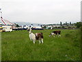
Llamas at the circus!
Mondao circus is here in Bury.
Peel tower on Holcombe Hill is seen in the background
Image: © liz dawson
Taken: 10 Jun 2007
0.14 miles
9
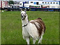
Llama in Walshaw
I assume this chap and his mate are part of the circus!
Image
Image: © liz dawson
Taken: 10 Jun 2007
0.15 miles