IMAGES TAKEN NEAR TO
Brookthorpe Road, BURY, BL8 3AB
Introduction
This page details the photographs taken nearby to Brookthorpe Road, BL8 3AB by members of the Geograph project.
The Geograph project started in 2005 with the aim of publishing, organising and preserving representative images for every square kilometre of Great Britain, Ireland and the Isle of Man.

There are currently over 7.5m images from over14,400 individuals and you can help contribute to the project by visiting https://www.geograph.org.uk
Image Map
Images are licensed for reuse under creativecommons.org/licenses/by-sa/2.0
Notes
- Clicking on the map will re-center to the selected point.
- The higher the marker number, the further away the image location is from the centre of the postcode.
Image Listing (36 Images Found)
Images are licensed for reuse under creativecommons.org/licenses/by-sa/2.0
Image
Details
Distance
7
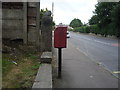
Walshaw Road, Bury
Showing position of Postbox No. BL8 66.
See Image] for postbox.
Image: © JThomas
Taken: 10 Sep 2018
0.14 miles
8
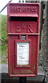
Elizabeth II postbox on Walshaw Road, Bury
Postbox No. BL8 66.
See Image] for context.
Image: © JThomas
Taken: 10 Sep 2018
0.14 miles
9
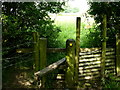
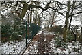
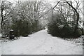
Stile
stile leading to beautiful meadow towards Walshaw
Image: © liz dawson
Taken: 10 Jun 2007
0.14 miles