IMAGES TAKEN NEAR TO
Otterbury Close, BURY, BL8 2TY
Introduction
This page details the photographs taken nearby to Otterbury Close, BL8 2TY by members of the Geograph project.
The Geograph project started in 2005 with the aim of publishing, organising and preserving representative images for every square kilometre of Great Britain, Ireland and the Isle of Man.

There are currently over 7.5m images from over14,400 individuals and you can help contribute to the project by visiting https://www.geograph.org.uk
Image Map
Images are licensed for reuse under creativecommons.org/licenses/by-sa/2.0
Notes
- Clicking on the map will re-center to the selected point.
- The higher the marker number, the further away the image location is from the centre of the postcode.
Image Listing (8 Images Found)
Images are licensed for reuse under creativecommons.org/licenses/by-sa/2.0
Image
Details
Distance
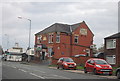
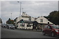
6
The car park of the Rose & Crown, Starling
This is viewed from Lowercroft Road and is more of a rear view of the pub, which faces onto Cockey Moor Road.
Image: © Bill Boaden
Taken: 19 Sep 2010
0.24 miles
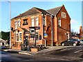
7
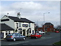
Rose & Crown with The Black Bull
Two pubs at the junction of Ainsworth Road, Lowercroft Road, Starling Road,and Cockey Moor Road Ainsworth.
Image: © Andrew Forrest
Taken: 8 Feb 2007
0.24 miles