IMAGES TAKEN NEAR TO
Bolton Road, BURY, BL8 2PA
Introduction
This page details the photographs taken nearby to Bolton Road, BL8 2PA by members of the Geograph project.
The Geograph project started in 2005 with the aim of publishing, organising and preserving representative images for every square kilometre of Great Britain, Ireland and the Isle of Man.

There are currently over 7.5m images from over14,400 individuals and you can help contribute to the project by visiting https://www.geograph.org.uk
Image Map
Images are licensed for reuse under creativecommons.org/licenses/by-sa/2.0
Notes
- Clicking on the map will re-center to the selected point.
- The higher the marker number, the further away the image location is from the centre of the postcode.
Image Listing (199 Images Found)
Images are licensed for reuse under creativecommons.org/licenses/by-sa/2.0
Image
Details
Distance
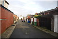
3
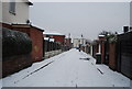
Cobbled back St in the snow off Grange Rd
Image: © N Chadwick
Taken: 19 Dec 2009
0.03 miles
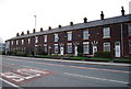
5
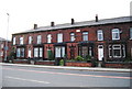
Goodwood Terrace, Bolton Rd
Built in 1882.
Image: © N Chadwick
Taken: 21 Mar 2009
0.03 miles
7
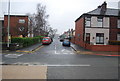
Grange Road
The house on the right hand side of the road was a "corner shop." It was converted to a private residence around 25 years ago.
Image: © N Chadwick
Taken: 20 Dec 2008
0.03 miles
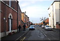
9
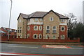
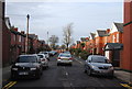
New housing development, Bolton Rd, Elton.
These flats are built on the site of the former Bolton Road Methodist church, which has been rebuilt up the road.
Image: © N Chadwick
Taken: 20 Dec 2008
0.04 miles
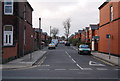
10
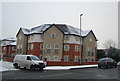
Flats, Bolton Rd
These are built on the site of the former Bolton Road Methodist Church.
Image: © N Chadwick
Taken: 19 Dec 2009
0.04 miles