IMAGES TAKEN NEAR TO
Fieldhead Avenue, BURY, BL8 2LX
Introduction
This page details the photographs taken nearby to Fieldhead Avenue, BL8 2LX by members of the Geograph project.
The Geograph project started in 2005 with the aim of publishing, organising and preserving representative images for every square kilometre of Great Britain, Ireland and the Isle of Man.

There are currently over 7.5m images from over14,400 individuals and you can help contribute to the project by visiting https://www.geograph.org.uk
Image Map
Images are licensed for reuse under creativecommons.org/licenses/by-sa/2.0
Notes
- Clicking on the map will re-center to the selected point.
- The higher the marker number, the further away the image location is from the centre of the postcode.
Image Listing (11 Images Found)
Images are licensed for reuse under creativecommons.org/licenses/by-sa/2.0
Image
Details
Distance
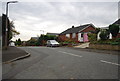
2
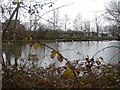
Pond and Chantlers Primary School
near Elton.
Image: © Margaret Clough
Taken: 23 Feb 2006
0.07 miles
6
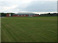
Elton Vale Cricket Club
Elton Vale CC are part of the sports club of the same name. The ground is on Elton Vale Road. The club have two teams in the North Manchester Cricket League.
Image: © BatAndBall
Taken: 20 Jun 2012
0.18 miles