IMAGES TAKEN NEAR TO
Mile Lane, BURY, BL8 2JW
Introduction
This page details the photographs taken nearby to Mile Lane, BL8 2JW by members of the Geograph project.
The Geograph project started in 2005 with the aim of publishing, organising and preserving representative images for every square kilometre of Great Britain, Ireland and the Isle of Man.

There are currently over 7.5m images from over14,400 individuals and you can help contribute to the project by visiting https://www.geograph.org.uk
Image Map
Images are licensed for reuse under creativecommons.org/licenses/by-sa/2.0
Notes
- Clicking on the map will re-center to the selected point.
- The higher the marker number, the further away the image location is from the centre of the postcode.
Image Listing (16 Images Found)
Images are licensed for reuse under creativecommons.org/licenses/by-sa/2.0
Image
Details
Distance
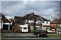
6
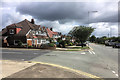
Bury and Bolton Road
Large semi-detached and detached houses on Bury and Bolton Road (A58).
Image: © David Dixon
Taken: 7 Jun 2017
0.17 miles
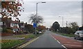
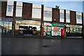
8
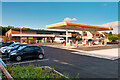
Spar Radcliffe Petrol Station
New shops and fuel forecourt on the site of the former Jolly Carters public house at the junction of Watling Street with Bury and Bolton Road (A58).
Image: © David Dixon
Taken: 15 Oct 2021
0.17 miles
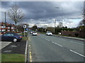
10
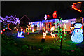
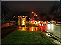
Early Christmas Lightshow on Bolton Road
Festive display outside a bungalow on Bolton Road; late November.
Image: © David Dixon
Taken: 26 Nov 2020
0.18 miles