IMAGES TAKEN NEAR TO
Edgworth Drive, BURY, BL8 2EB
Introduction
This page details the photographs taken nearby to Edgworth Drive, BL8 2EB by members of the Geograph project.
The Geograph project started in 2005 with the aim of publishing, organising and preserving representative images for every square kilometre of Great Britain, Ireland and the Isle of Man.

There are currently over 7.5m images from over14,400 individuals and you can help contribute to the project by visiting https://www.geograph.org.uk
Image Map
Images are licensed for reuse under creativecommons.org/licenses/by-sa/2.0
Notes
- Clicking on the map will re-center to the selected point.
- The higher the marker number, the further away the image location is from the centre of the postcode.
Image Listing (6 Images Found)
Images are licensed for reuse under creativecommons.org/licenses/by-sa/2.0
Image
Details
Distance
3
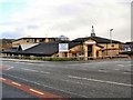
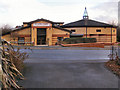
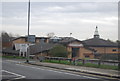
Bolton Road Methodist Church
The existing Bolton Road Methodist church was replaced with this new church which opened in 2002. The sports club on the adjoining land had been sold for housing to finance the building of the new church.
Image: © David Dixon
Taken: 9 Feb 2010
0.20 miles