IMAGES TAKEN NEAR TO
Oakham Close, BURY, BL8 1XJ
Introduction
This page details the photographs taken nearby to Oakham Close, BL8 1XJ by members of the Geograph project.
The Geograph project started in 2005 with the aim of publishing, organising and preserving representative images for every square kilometre of Great Britain, Ireland and the Isle of Man.

There are currently over 7.5m images from over14,400 individuals and you can help contribute to the project by visiting https://www.geograph.org.uk
Image Map (Loading...)


Getting Data...Please wait
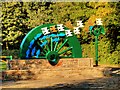
Leaflet Map data © OpenStreetMap
Images are licensed for reuse under creativecommons.org/licenses/by-sa/2.0
Notes
- Clicking on the map will re-center to the selected point.
- The higher the marker number, the further away the image location is from the centre of the postcode.
Image Listing (23 Images Found)
Images are licensed for reuse under creativecommons.org/licenses/by-sa/2.0
Image
Details
Distance
1
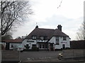
The Garsdale public house at Higher Woodhill
Image: © John Slater
Taken: 10 Apr 2015
0.06 miles
2
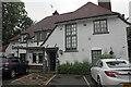
The Garsdale, Woodhill Road, Bury
Built in 1925 as a manager's house for the Star Bleaching Company by 1933 and the Great Depression it saw closure of the bleaching and dye works and former Burrs Mill. Formerly a Wilsons Brewery Ltd house the Garsdale first opened its doors in 1980.
Image: © Jo and Steve Turner
Taken: 19 Aug 2021
0.07 miles
3
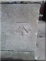
Ordnance Survey Cut Mark
This can be found on a wall at Higher Woodhill.
For more detail see : http://www.bench-marks.org.uk/bm50450
Image: © Peter Wood
Taken: 31 Jul 2013
0.07 miles
4
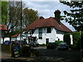
The Garsdale
Country inn and restaurant near Bury.
Image: © John H Darch
Taken: 15 May 2010
0.09 miles
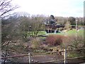
6
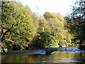
River Irwell
Taken from the bank looking down River at Burrs Country Park.
Image: © Paul Rudge
Taken: 25 Jun 2006
0.14 miles
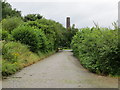
7
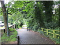
Cobbled Track with barrier and stile through Burrs Country Park
Looking north-eastward.
Image: © Peter Wood
Taken: 3 Aug 2017
0.15 miles
8
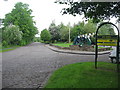
Entrance to Burrs Country Park
The approach to Burrs is via this cobbled road
Bury Council acquired Burrs in 1986 and since then the site has been transformed from a derelict industrial site to a modern country park.
For more information about the park click on http://www.burrs.org.uk/park.htm
Image: © Paul Anderson
Taken: 13 May 2007
0.16 miles
9
The cobbled Woodhill Road in Burrs Country Park
Looking north-westward towards the Activity Centre.
Image: © Peter Wood
Taken: 3 Aug 2017
0.19 miles
10
River Irwell near Burrs Country Park
View from East Lancs Railway
Image: © Raymond Knapman
Taken: 26 Feb 2011
0.19 miles