IMAGES TAKEN NEAR TO
Retford Close, BURY, BL8 1XG
Introduction
This page details the photographs taken nearby to Retford Close, BL8 1XG by members of the Geograph project.
The Geograph project started in 2005 with the aim of publishing, organising and preserving representative images for every square kilometre of Great Britain, Ireland and the Isle of Man.

There are currently over 7.5m images from over14,400 individuals and you can help contribute to the project by visiting https://www.geograph.org.uk
Image Map
Images are licensed for reuse under creativecommons.org/licenses/by-sa/2.0
Notes
- Clicking on the map will re-center to the selected point.
- The higher the marker number, the further away the image location is from the centre of the postcode.
Image Listing (78 Images Found)
Images are licensed for reuse under creativecommons.org/licenses/by-sa/2.0
Image
Details
Distance
2
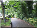
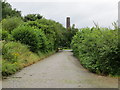
Cobbled Track with barrier and stile through Burrs Country Park
Looking north-eastward.
Image: © Peter Wood
Taken: 3 Aug 2017
0.05 miles
3
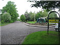
Entrance to Burrs Country Park
The approach to Burrs is via this cobbled road
Bury Council acquired Burrs in 1986 and since then the site has been transformed from a derelict industrial site to a modern country park.
For more information about the park click on http://www.burrs.org.uk/park.htm
Image: © Paul Anderson
Taken: 13 May 2007
0.06 miles
4
River Irwell near Burrs Country Park
View from East Lancs Railway
Image: © Raymond Knapman
Taken: 26 Feb 2011
0.08 miles
5
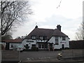
The Garsdale public house at Higher Woodhill
Image: © John Slater
Taken: 10 Apr 2015
0.09 miles
6
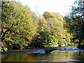
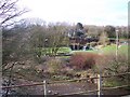
River Irwell
Taken from the bank looking down River at Burrs Country Park.
Image: © Paul Rudge
Taken: 25 Jun 2006
0.10 miles
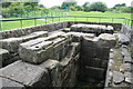
7
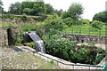
Wheel pit, Higher Woodhill Mill site
Pit for a breast shot wheel of about 1850. The foliage could do with a trim.
Image: © Chris Allen
Taken: 4 Jul 2009
0.10 miles
8
The cobbled Woodhill Road in Burrs Country Park
Looking north-westward towards the Activity Centre.
Image: © Peter Wood
Taken: 3 Aug 2017
0.10 miles
9
Beam engine foundations, Higher Woodhill Mill site
Bed for a 100 horsepower beam engine (allegedly 100 horsepower). The crankpit is closest with the cross wall to support the columns for the entablature in the middle and the cylinder pad beyond. This looks like it was a single cylinder engine on the available evidence.
Image: © Chris Allen
Taken: 4 Jul 2009
0.10 miles
10
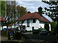
The Garsdale
Country inn and restaurant near Bury.
Image: © John H Darch
Taken: 15 May 2010
0.11 miles