IMAGES TAKEN NEAR TO
Wash Terrace, BURY, BL8 1TY
Introduction
This page details the photographs taken nearby to Wash Terrace, BL8 1TY by members of the Geograph project.
The Geograph project started in 2005 with the aim of publishing, organising and preserving representative images for every square kilometre of Great Britain, Ireland and the Isle of Man.

There are currently over 7.5m images from over14,400 individuals and you can help contribute to the project by visiting https://www.geograph.org.uk
Image Map
Images are licensed for reuse under creativecommons.org/licenses/by-sa/2.0
Notes
- Clicking on the map will re-center to the selected point.
- The higher the marker number, the further away the image location is from the centre of the postcode.
Image Listing (18 Images Found)
Images are licensed for reuse under creativecommons.org/licenses/by-sa/2.0
Image
Details
Distance
1
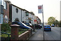
Bus stop by the Lamb Inn
This is on Bury Road Tottington, and the Lamb Inn is the official name for this stop.
Image: © Bill Boaden
Taken: 20 Apr 2011
0.08 miles
3
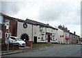
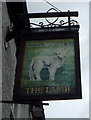
The Lamb public House, Woolfold
On Tottington Road.
Image: © JThomas
Taken: 17 Sep 2018
0.11 miles
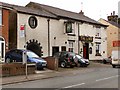
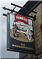
6
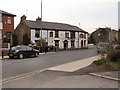
The Waggonmakers Arms, Woolfold
On Tottington Road.
Image: © JThomas
Taken: 17 Sep 2018
0.14 miles
8

Cycle Trap
This contraption has been installed on the Bury to Holcombe Cycle Way to make cyclists dismount before a narrow bend.
Try going through on a bike and you come out the other side minus your handle bars!
Just around the corner from this location the cycle way takes the route of the old Bury to Holcombe Brook Railway line see http://www.bikerides.dsracing.me.uk/routes/holcombe.htm
Image: © Paul Anderson
Taken: 23 Mar 2007
0.16 miles
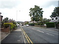
9
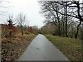
Cycle path at Woolfold
The path follows the route of the former railway of the Tottington branch. At this point houses on the left of the view have been built on the site of Woolfold station.
Image: © Kevin Waterhouse
Taken: 3 Feb 2023
0.20 miles