IMAGES TAKEN NEAR TO
Chiltern Drive, BURY, BL8 1QY
Introduction
This page details the photographs taken nearby to Chiltern Drive, BL8 1QY by members of the Geograph project.
The Geograph project started in 2005 with the aim of publishing, organising and preserving representative images for every square kilometre of Great Britain, Ireland and the Isle of Man.

There are currently over 7.5m images from over14,400 individuals and you can help contribute to the project by visiting https://www.geograph.org.uk
Image Map (Loading...)


Getting Data...Please wait
Leaflet Map data © OpenStreetMap
Images are licensed for reuse under creativecommons.org/licenses/by-sa/2.0
Notes
- Clicking on the map will re-center to the selected point.
- The higher the marker number, the further away the image location is from the centre of the postcode.
Image Listing (41 Images Found)
Images are licensed for reuse under creativecommons.org/licenses/by-sa/2.0
Image
Details
Distance
1
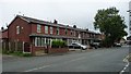
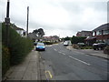
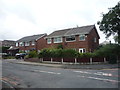
Terraced houses, south side of Walshaw Road, Bury
With a continuous slope on their roofs and the tops of their bay windows.
Image: © Christine Johnstone
Taken: 6 Sep 2018
0.07 miles
7
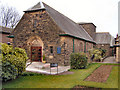
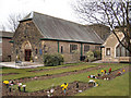
The Parish Church of St James, Woolfold
Image: © Alexander P Kapp
Taken: 21 Sep 2005
0.12 miles
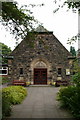
8
The Parish Church of St James, Woolfold
Image: © Alexander P Kapp
Taken: 21 Sep 2005
0.12 miles
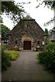
10
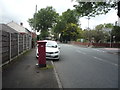
Walshaw Road, Bury
Showing position of Postbox No. BL8 48.
See Image] for postbox.
Image: © JThomas
Taken: 10 Sep 2018
0.13 miles