IMAGES TAKEN NEAR TO
Tottington Road, BURY, BL8 1JY
Introduction
This page details the photographs taken nearby to Tottington Road, BL8 1JY by members of the Geograph project.
The Geograph project started in 2005 with the aim of publishing, organising and preserving representative images for every square kilometre of Great Britain, Ireland and the Isle of Man.

There are currently over 7.5m images from over14,400 individuals and you can help contribute to the project by visiting https://www.geograph.org.uk
Image Map
Images are licensed for reuse under creativecommons.org/licenses/by-sa/2.0
Notes
- Clicking on the map will re-center to the selected point.
- The higher the marker number, the further away the image location is from the centre of the postcode.
Image Listing (50 Images Found)
Images are licensed for reuse under creativecommons.org/licenses/by-sa/2.0
Image
Details
Distance
1
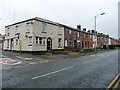
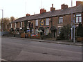
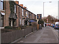
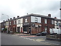
Housing on the south side of Tottington Road, Bury
Near the junction with Orrell Street. The white building [now flats] was formerly the Pleasant View Inn Image
Image: © Christine Johnstone
Taken: 6 Sep 2018
0.06 miles
4
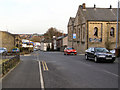
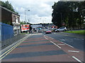
Walshaw Road
Looking down Walshaw Road, past the "Clever Clogs" childcare centre on Orrell Street, towards Crostons.
Image: © David Dixon
Taken: 16 Mar 2010
0.09 miles
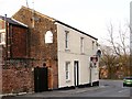
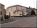
6
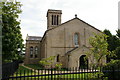
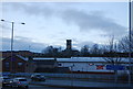
All Saints Church
Now converted into flats
Image: © Alexander P Kapp
Taken: 21 Sep 2005
0.09 miles