IMAGES TAKEN NEAR TO
Camp Street, BURY, BL8 1FE
Introduction
This page details the photographs taken nearby to Camp Street, BL8 1FE by members of the Geograph project.
The Geograph project started in 2005 with the aim of publishing, organising and preserving representative images for every square kilometre of Great Britain, Ireland and the Isle of Man.

There are currently over 7.5m images from over14,400 individuals and you can help contribute to the project by visiting https://www.geograph.org.uk
Image Map
Images are licensed for reuse under creativecommons.org/licenses/by-sa/2.0
Notes
- Clicking on the map will re-center to the selected point.
- The higher the marker number, the further away the image location is from the centre of the postcode.
Image Listing (55 Images Found)
Images are licensed for reuse under creativecommons.org/licenses/by-sa/2.0
Image
Details
Distance
1
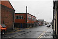
CK Appliances
Supplier of very good value white goods and appliances.
Image: © Bill Boaden
Taken: 19 Sep 2010
0.02 miles
2
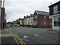
Older houses, east side of Harvey Street, Bury
There are several terraces of this pattern in the area.
Image: © Christine Johnstone
Taken: 6 Sep 2018
0.03 miles
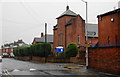
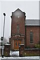
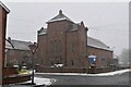
8
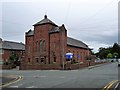
Guardian Angels in Bury
The Roman Catholic parish church on Harvey Street.
Image: © Christine Johnstone
Taken: 6 Sep 2018
0.06 miles
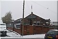
9
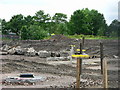
site of Old Mill
This is where the water marked on the OS should be!
Image: © liz dawson
Taken: 17 Jun 2007
0.06 miles
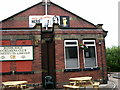
10
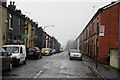
Wood Street, Elton
This fulfils the southern stereotype of 'up north'.
Image: © Bill Boaden
Taken: 19 Sep 2010
0.07 miles