IMAGES TAKEN NEAR TO
Wroxham Close, BURY, BL8 1EN
Introduction
This page details the photographs taken nearby to Wroxham Close, BL8 1EN by members of the Geograph project.
The Geograph project started in 2005 with the aim of publishing, organising and preserving representative images for every square kilometre of Great Britain, Ireland and the Isle of Man.

There are currently over 7.5m images from over14,400 individuals and you can help contribute to the project by visiting https://www.geograph.org.uk
Image Map
Images are licensed for reuse under creativecommons.org/licenses/by-sa/2.0
Notes
- Clicking on the map will re-center to the selected point.
- The higher the marker number, the further away the image location is from the centre of the postcode.
Image Listing (22 Images Found)
Images are licensed for reuse under creativecommons.org/licenses/by-sa/2.0
Image
Details
Distance
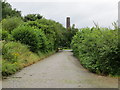
1
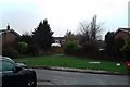
Open land on the corner of Dereham Close
Image: © Anthony Parkes
Taken: 24 Feb 2017
0.11 miles
2
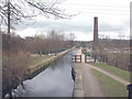
Feeder aqueduct
This aqueduct carries the feeder for Elton reservoir Image over the river Irwell from the upstream weir. http://www.geograph.org.uk/gridref/SD7913
Image: © Dennis Turner
Taken: 20 Mar 2006
0.18 miles
3
Aqueduct
Carrying a reservoir feeder over the River Irwell at Burrs.
Image: © Dennis Turner
Taken: 20 Mar 2006
0.18 miles
4
River Irwell at Burrs
Section of the river adjacent to the Burrs Activity Centre. http://www.burrs.org.uk/
Image: © Dennis Turner
Taken: 18 Mar 2006
0.21 miles
5
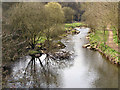
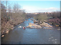
River Irwell at Burrs
Looking upstream from the Aqueduct.
Image: © David Dixon
Taken: 10 Apr 2010
0.21 miles
7
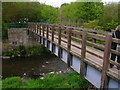
Footbridge over River Irwell, Burrs Country Park
Image: © John H Darch
Taken: 15 May 2010
0.22 miles
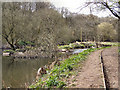
8
The cobbled Woodhill Road in Burrs Country Park
Looking north-westward towards the Activity Centre.
Image: © Peter Wood
Taken: 3 Aug 2017
0.22 miles
9
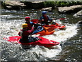
Kayakers at the Burrs Activity Centre
Kayakers playing on a wave on the River Irwell at the Burrs Activity Centre.
The Burrs Activity Centre is based on one of Bury's oldest industrial sites. The River Irwell, which meanders through the site, is used as a canoeing centre with difficulty levels up to grade 2/3.
Image: © Martin Stockdale
Taken: 8 May 2005
0.22 miles
10
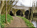
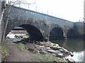
The Aqueduct at Burrs
The blue brick aqueduct, crossing the Irwell, carries the feeder channel for the Manchester, Bolton and Bury Canal.
Image: © David Dixon
Taken: 10 Apr 2010
0.23 miles