IMAGES TAKEN NEAR TO
Brandlesholme Road, BURY, BL8 1AS
Introduction
This page details the photographs taken nearby to Brandlesholme Road, BL8 1AS by members of the Geograph project.
The Geograph project started in 2005 with the aim of publishing, organising and preserving representative images for every square kilometre of Great Britain, Ireland and the Isle of Man.

There are currently over 7.5m images from over14,400 individuals and you can help contribute to the project by visiting https://www.geograph.org.uk
Image Map (Loading...)


Getting Data...Please wait
Leaflet Map data © OpenStreetMap
Images are licensed for reuse under creativecommons.org/licenses/by-sa/2.0
Notes
- Clicking on the map will re-center to the selected point.
- The higher the marker number, the further away the image location is from the centre of the postcode.
Image Listing (24 Images Found)
Images are licensed for reuse under creativecommons.org/licenses/by-sa/2.0
Image
Details
Distance
1
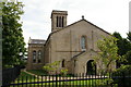
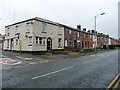
All Saints Church
Now converted into flats
Image: © Alexander P Kapp
Taken: 21 Sep 2005
0.13 miles
4
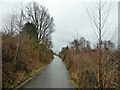
Former railway route of the Tottington branch line
View on the cycle way up to Brandlesholme Close
Image: © Kevin Waterhouse
Taken: 3 Feb 2023
0.16 miles
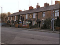
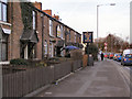
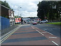
8
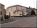
Housing on the south side of Tottington Road, Bury
Near the junction with Orrell Street. The white building [now flats] was formerly the Pleasant View Inn Image
Image: © Christine Johnstone
Taken: 6 Sep 2018
0.17 miles
10
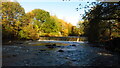
Bury - Weir on River Irwell off Woodhill Road
Image: © Colin Park
Taken: 13 Nov 2021
0.19 miles