IMAGES TAKEN NEAR TO
Revers Street, BURY, BL8 1AQ
Introduction
This page details the photographs taken nearby to Revers Street, BL8 1AQ by members of the Geograph project.
The Geograph project started in 2005 with the aim of publishing, organising and preserving representative images for every square kilometre of Great Britain, Ireland and the Isle of Man.

There are currently over 7.5m images from over14,400 individuals and you can help contribute to the project by visiting https://www.geograph.org.uk
Image Map (Loading...)


Getting Data...Please wait
Leaflet Map data © OpenStreetMap
Images are licensed for reuse under creativecommons.org/licenses/by-sa/2.0
Notes
- Clicking on the map will re-center to the selected point.
- The higher the marker number, the further away the image location is from the centre of the postcode.
Image Listing (88 Images Found)
Images are licensed for reuse under creativecommons.org/licenses/by-sa/2.0
Image
Details
Distance
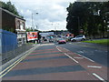
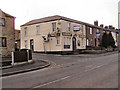
4
Dusty Miller
The Junction of Crostons Road and Tottington Road.
The direction post, partially hidden by the traffic light pole, is a grade II listed structure. It is dated 1834.
Image: © David Dixon
Taken: 16 Mar 2010
0.09 miles
5
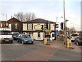
Dusty Miller
The Junction of Crostons Road and Tottington Road.
The direction post, visible behind the blue car, is a grade II listed structure. It is dated 1834.
Image: © David Dixon
Taken: 16 Mar 2010
0.09 miles
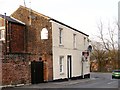
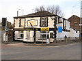
6
The junction of Tottington Road with Crostons Road
This is taken from Walshaw Road which joins Tottington Road at this point. The old police station is the large building in the background.
Image: © Bill Boaden
Taken: 19 Sep 2010
0.09 miles
7
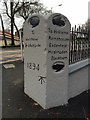
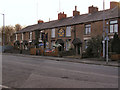
Old Guide Stone by the B6213, Tottington Road, Bury parish
Guide Stone by the B6213, in parish of Bury (Bury District), Tottington Road, in front of Dusty Miller PH, on pavement.
Inscription reads:-
: {<-hand} / To / Tottington / & Edgworth / {hand->} / To Bury : : {<-hand} / To / Walshaw / & Afettside / 1834 : : {hand->} / To Holcome / Ramsbottom / Eadenfield / Haslingdon / Blackburn / {<-hand} :
Carved bench mark on South face.
Grade II listed twice.
List Entry Number: 1067263 https://historicengland.org.uk/listing/the-list/list-entry/1067263
List Entry Number: 1250812 https://historicengland.org.uk/listing/the-list/list-entry/1250812
Surveyed
Milestone Society National ID: LA_XBUR01
Image: © Milestone Society
Taken: Unknown
0.10 miles
8
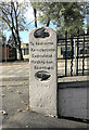
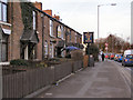
Old Guide Stone by the B6213, Tottington Road, Bury parish
Guide Stone by the B6213, in parish of Bury (Bury District), Tottington Road, in front of Dusty Miller PH, on pavement. An earlier photograph can be found here https://www.geograph.org.uk/photo/6050246.
Inscription reads:-
: {<-hand} / To / Tottington / & Edgworth / {hand->} / To Bury : : {<-hand} / To / Walshaw / & Afettside / 1834 : : {hand->} / To Holcome / Ramsbottom / Eadenfield / Haslingdon / Blackburn / {<-hand} :
Carved bench mark on South face.
Grade II listed twice.
List Entry Number: 1067263 https://historicengland.org.uk/listing/the-list/list-entry/1067263
List Entry Number: 1250812 https://historicengland.org.uk/listing/the-list/list-entry/1250812
Milestone Society National ID: LA_XBUR01
Image: © Sue Cameron
Taken: 20 Jun 2023
0.10 miles