IMAGES TAKEN NEAR TO
Lower Woodhill Road, BURY, BL8 1AA
Introduction
This page details the photographs taken nearby to Lower Woodhill Road, BL8 1AA by members of the Geograph project.
The Geograph project started in 2005 with the aim of publishing, organising and preserving representative images for every square kilometre of Great Britain, Ireland and the Isle of Man.

There are currently over 7.5m images from over14,400 individuals and you can help contribute to the project by visiting https://www.geograph.org.uk
Image Map
Images are licensed for reuse under creativecommons.org/licenses/by-sa/2.0
Notes
- Clicking on the map will re-center to the selected point.
- The higher the marker number, the further away the image location is from the centre of the postcode.
Image Listing (194 Images Found)
Images are licensed for reuse under creativecommons.org/licenses/by-sa/2.0
Image
Details
Distance
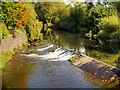
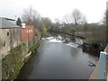
3
River Irwell above the Weir at Bury Bridge
Image: © David Dixon
Taken: 17 Sep 2019
0.03 miles
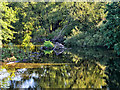
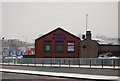
4

The River Irwell at Bury Bridge
With Bury Bridge Working Men's Club to the left
Image: © Neil Theasby
Taken: 30 Jan 2016
0.03 miles
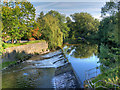
5
Weir on the River Irwell near Bury Ground
Image: © John Slater
Taken: 10 Apr 2015
0.04 miles
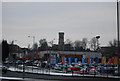
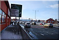
8
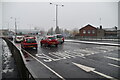
Vauxhall dealership near Bury Bridge.
One of several car dealerships located close to this major road junction.
Image: © N Chadwick
Taken: 20 Dec 2008
0.05 miles
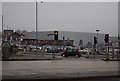
9
Bury Bridge
The A58 crosses the River Irwell.
Image: © N Chadwick
Taken: 18 Dec 2010
0.06 miles