IMAGES TAKEN NEAR TO
Cox Green Road, BOLTON, BL7 9RJ
Introduction
This page details the photographs taken nearby to Cox Green Road, BL7 9RJ by members of the Geograph project.
The Geograph project started in 2005 with the aim of publishing, organising and preserving representative images for every square kilometre of Great Britain, Ireland and the Isle of Man.

There are currently over 7.5m images from over14,400 individuals and you can help contribute to the project by visiting https://www.geograph.org.uk
Image Map
Images are licensed for reuse under creativecommons.org/licenses/by-sa/2.0
Notes
- Clicking on the map will re-center to the selected point.
- The higher the marker number, the further away the image location is from the centre of the postcode.
Image Listing (16 Images Found)
Images are licensed for reuse under creativecommons.org/licenses/by-sa/2.0
Image
Details
Distance
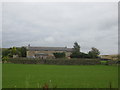
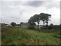
3
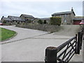
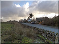
New Butterworths Farm
Gentrified in the late twentieth century, this farm complex sits at the base of Turton Moor overlooking the village of Egerton.
Image: © John Tustin
Taken: 21 Apr 2009
0.11 miles
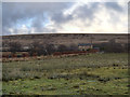
7
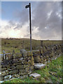
Stile and Signpost
Leading to the moorland from Cox Green Road.
Image: © David Dixon
Taken: 4 Dec 2012
0.17 miles
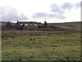
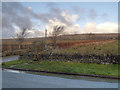
10
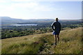
Cheetham Close Southern Slopes
The path from Chapeltown to Dimple crosses the southern flanks of Cheetham Close Hill. This photo shows the descent to Lynwood with Delph Reservoir in the distance.
Image: © Peter Standing
Taken: 9 Sep 2006
0.20 miles