IMAGES TAKEN NEAR TO
Crossfields, BOLTON, BL7 9NH
Introduction
This page details the photographs taken nearby to Crossfields, BL7 9NH by members of the Geograph project.
The Geograph project started in 2005 with the aim of publishing, organising and preserving representative images for every square kilometre of Great Britain, Ireland and the Isle of Man.

There are currently over 7.5m images from over14,400 individuals and you can help contribute to the project by visiting https://www.geograph.org.uk
Image Map
Images are licensed for reuse under creativecommons.org/licenses/by-sa/2.0
Notes
- Clicking on the map will re-center to the selected point.
- The higher the marker number, the further away the image location is from the centre of the postcode.
Image Listing (20 Images Found)
Images are licensed for reuse under creativecommons.org/licenses/by-sa/2.0
Image
Details
Distance
1
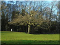
Bromley Cross
Taken on Grange Road at the south western end of Jumbles Reservoir, near Bolton, Lancashire, I am looking across the green and the railway line to Hillside Avenue. The sharp-eyed may be able to spot the host of fieldfares on this section of green (there were also lots of redwings further up towards Horrobin).
Image: © Carroll Pierce
Taken: 26 Dec 2016
0.06 miles
3
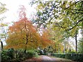
Ousel Nest Meadows
Ousel Nest Meadows lie within the Jumbles Country Park, to the south of the reservoir.
The following is taken from an information board at the site.
“Ousel is the old English word for the Blackbird, although it is possible that its cousin the Ring Ousel may have nested close to Bradshaw Brook in the past.
Grazing or mowing has not taken place at the site for several years allowing young Oak and Birch trees to start regenerating. This has been helped along by the planting of 4000 young native broadleaves by Bolton Metro and local interest groups during the winter of 1996-7”
Image: © David Dixon
Taken: 17 Apr 2011
0.17 miles
5
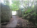
Rotary Way under the railway at Bromley Cross
Image: © John Slater
Taken: 26 Sep 2015
0.18 miles
6
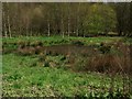
Pond in a marshy field
The fields here alongside Bradshaw Brook were previously cleared for grazing but are now being allowed to return to woodland and marshland, with the help of some broadleaf tree planting by the Local Authority.
Image: © philandju
Taken: 22 Apr 2012
0.18 miles
7

Ousel Nest Meadows
Ousel Nest Meadows lie within the Jumbles Country Park, to the south of the reservoir.
The following is taken from an information board at the site.
“Ousel is the old English word for the Blackbird, although it is possible that its cousin the Ring Ousel may have nested close to Bradshaw Brook in the past.
Grazing or mowing has not taken place at the site for several years allowing young Oak and Birch trees to start regenerating. This has been helped along by the planting of 4000 young native broadleaves by Bolton Metro and local interest groups during the winter of 1996-7”
Image: © David Dixon
Taken: 17 Apr 2011
0.19 miles
8
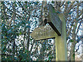
Waymarket at Ousels Nest
Taken on Grange Road at the south western end of Jumbles Reservoir, Bolton, Lancashire.
Image: © Carroll Pierce
Taken: 26 Dec 2016
0.20 miles
9

Ousel Nest Meadows
Ousel Nest Meadows lie within the Jumbles Country Park, to the south of the reservoir.
The following is taken from an information board at the site.
“Ousel is the old English word for the Blackbird, although it is possible that its cousin the Ring Ousel may have nested close to Bradshaw Brook in the past.
Grazing or mowing has not taken place at the site for several years allowing young Oak and Birch trees to start regenerating. This has been helped along by the planting of 4000 young native broadleaves by Bolton Metro and local interest groups during the winter of 1996-7.”
Image: © David Dixon
Taken: 17 Apr 2011
0.20 miles
10
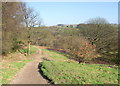
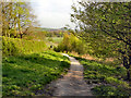
Footpath to the Jumbles
The Jumbles is now a nature park dominated by a reservoir. Before the reservoir was built in the 1960s this path then led down to the "Old Jumbles" - a wooded valley through which Bradshaw Brook flowed. Now the path brings you to the reservoir dam.
Image: © Phil Platt
Taken: 3 Mar 2011
0.20 miles