IMAGES TAKEN NEAR TO
Hough Lane, BOLTON, BL7 9DE
Introduction
This page details the photographs taken nearby to Hough Lane, BL7 9DE by members of the Geograph project.
The Geograph project started in 2005 with the aim of publishing, organising and preserving representative images for every square kilometre of Great Britain, Ireland and the Isle of Man.

There are currently over 7.5m images from over14,400 individuals and you can help contribute to the project by visiting https://www.geograph.org.uk
Image Map
Images are licensed for reuse under creativecommons.org/licenses/by-sa/2.0
Notes
- Clicking on the map will re-center to the selected point.
- The higher the marker number, the further away the image location is from the centre of the postcode.
Image Listing (67 Images Found)
Images are licensed for reuse under creativecommons.org/licenses/by-sa/2.0
Image
Details
Distance
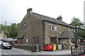
1
Spread Eagle at Eagley
On Hough Lane. In days past, Hough Lane met Eagley Way, and before that, Eagley Brow, at Eagley Brook and was a short cut between Bromley Cross and Astley Bridge. However, the route became a dangerous rat run and Hough Lane is now a cul de sac just lower down the hill from the pub.
Image: © philandju
Taken: 6 Jan 2012
0.03 miles
2
The Spread Eagle
On Hough Lane. In days past, Hough Lane met Eagley Way, and before that, Eagley Brow, at Eagley Brook and was a short cut between Bromley Cross and Astley Bridge. However, the route became a dangerous rat run and Hough Lane is now a cul de sac just lower down the hill from the pub.
Image: © philandju
Taken: 2 Feb 2018
0.04 miles
3
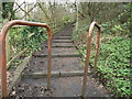
Little Brow, Eagley
The path climbs the hill between Eagley and Bromley Cross.
Image: © philandju
Taken: 6 Jan 2012
0.05 miles
4
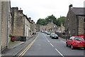
Hough Lane, Eagley
Once a through road, the main street of Eagley is now a residential backwater.
Image: © Alan Murray-Rust
Taken: 25 Jul 2012
0.06 miles
5
The Old School House, Hough Lane
18th century stone building with mullioned windows, which appears to have been used as the local school before the new school was built in 1852. It currently again serves an educational purpose as it houses a nursery school.
Image: © Alan Murray-Rust
Taken: 25 Jul 2012
0.06 miles
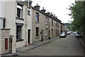
6
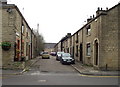
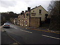
Millworkers' stone cottages
School Street Eagley (in North Bolton). Eagley cotton mills were 100 metres away. The old schoolbuilding (now apartments) is at the top of the street.
Image: © Phil Platt
Taken: 26 Mar 2011
0.07 miles
7
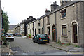
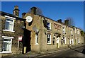
School Street, Eagley
A typical street of early to mid 19th century mill-workers' cottages. The nearer group on the right were built as back-to-back houses around 1830, but each back-to-back pair has now been merged into a single dwelling.
Image: © Alan Murray-Rust
Taken: 25 Jul 2012
0.07 miles
8
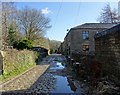
Paper Mill Road, Eagley
Also spelled Papermill Road. The mill has long since disappeared, but the cobbles, or setts, remain.
Image: © philandju
Taken: 2 Feb 2018
0.07 miles
9
School Street, Eagley
A typical street of early to mid 19th century mill-workers' cottages. Looking east from near the old school.
Image: © Alan Murray-Rust
Taken: 25 Jul 2012
0.09 miles
10
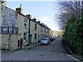
School Street, Eagley
Looking east from the old school yard. The old school is now converted to private residences.
Image: © philandju
Taken: 2 Feb 2018
0.09 miles