IMAGES TAKEN NEAR TO
Walton Fold, BOLTON, BL7 0QB
Introduction
This page details the photographs taken nearby to Walton Fold, BL7 0QB by members of the Geograph project.
The Geograph project started in 2005 with the aim of publishing, organising and preserving representative images for every square kilometre of Great Britain, Ireland and the Isle of Man.

There are currently over 7.5m images from over14,400 individuals and you can help contribute to the project by visiting https://www.geograph.org.uk
Image Map
Images are licensed for reuse under creativecommons.org/licenses/by-sa/2.0
Notes
- Clicking on the map will re-center to the selected point.
- The higher the marker number, the further away the image location is from the centre of the postcode.
Image Listing (16 Images Found)
Images are licensed for reuse under creativecommons.org/licenses/by-sa/2.0
Image
Details
Distance
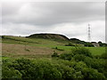
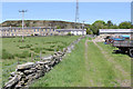
1
View to Round Barn
This small community takes its name from Round Barn Farm, at the right hand side. The terrace of cottages would have been built to provide accommodation for workers at the quarry on the hillside behind. The line of the tramroad http://www.geograph.org.uk/photo/3495956 running down from the quarry to the railway in the valley bottom can be seen running diagonally from the white house to the bottom right corner of the picture.
Image: © Alan Murray-Rust
Taken: 4 Jun 2013
0.02 miles
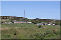
2

Footpath about to cross Blackburn Road at Round Barn
Image: © Bill Boaden
Taken: 21 Aug 2010
0.03 miles
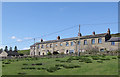
3

Round Barn
One of several groups of houses along Blackburn Road. A footpath crosses at this point.
Image: © Bill Boaden
Taken: 21 Aug 2010
0.03 miles
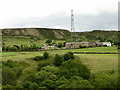
4
Round Barn
This small community, originally quarrymen's dwellings, takes it name from the adjacent Round Barn Farm.
Image: © Alan Murray-Rust
Taken: 4 Jun 2013
0.04 miles
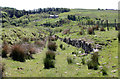
6
Tramroad at Round Barn (1)
This tramroad linked the quarry behind the houses with the railway in the bottom of the valley.
It had at least 3 phases of existence. The 1894 25inch shows it as a disused tramway, indicating an earlier phase of existence, probably narrow gauge. By 1910 it has been reinstated as a narrow gauge tramway, by this stage also serving a brickworks adjacent to the railway. by 1929 it is shown as a standard gauge mineral railway connected into the main line. In all phases it was certainly a rope-worked incline, as it is far too steep for locomotive haulage. It had then clearly ceased operation by the 1950s, probably significantly earlier.
It is now a public footpath.
Image: © Alan Murray-Rust
Taken: 4 Jun 2013
0.06 miles
7

An old steam engine in the garden
This is the boiler, sited near some cottages on Roman Road.
Image: © Bill Boaden
Taken: 21 Aug 2010
0.10 miles
8
Tramroad at Round Barn (2)
This is the lower portion of the tramroad seen in http://www.geograph.org.uk/photo/3495956. As can be seen, some considerable earthworks were necessary to maintain an even gradient.
Image: © Alan Murray-Rust
Taken: 4 Jun 2013
0.12 miles
9
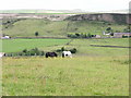
View down Valley north of Edgeworth
Roman Road running along the bottom and Aushaw Moss in the distance
Image: © liz dawson
Taken: 23 Jun 2007
0.15 miles