IMAGES TAKEN NEAR TO
Blackburn Road, BOLTON, BL7 0PW
Introduction
This page details the photographs taken nearby to Blackburn Road, BL7 0PW by members of the Geograph project.
The Geograph project started in 2005 with the aim of publishing, organising and preserving representative images for every square kilometre of Great Britain, Ireland and the Isle of Man.

There are currently over 7.5m images from over14,400 individuals and you can help contribute to the project by visiting https://www.geograph.org.uk
Image Map
Images are licensed for reuse under creativecommons.org/licenses/by-sa/2.0
Notes
- Clicking on the map will re-center to the selected point.
- The higher the marker number, the further away the image location is from the centre of the postcode.
Image Listing (25 Images Found)
Images are licensed for reuse under creativecommons.org/licenses/by-sa/2.0
Image
Details
Distance
1
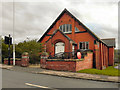
St James' Church
Blackburn Road, Edgworth.
Image: © David Dixon
Taken: 6 Oct 2010
0.03 miles
2
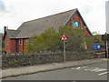
St James' Church, Edgworth
Blackburn Road.
Image: © David Dixon
Taken: 6 Oct 2010
0.03 miles
3
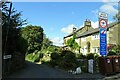
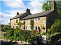
Hob Lane
A narrow lane leading from Edgworth over Wayoh Reservoir to Entwistle. The houses on the right are Grade II listed.
Image: © philandju
Taken: 16 Sep 2022
0.03 miles
4
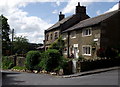
Cottages at Hob Lane
At the junction of Hob Lane and Blackburn Road in Edgworth. An old gentleman takes his ease in the afternoon sun.
Image: © Phil and Juliette Platt
Taken: 8 May 2011
0.03 miles
5

St. James' Church Edgworth
Church of England church in the parish of St. Anne, Chapeltown.
Image: © Phil and Juliette Platt
Taken: 8 May 2011
0.03 miles
6
Cottage on Hob Lane
The cottage on the right was built in 1717 and stands at the junction of Hob Lane and Blackburn Road on the outskirts of Edgworth.
Image: © Paul Anderson
Taken: 26 Sep 2007
0.05 miles
7
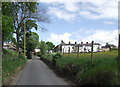
Looking up Hob Lane
A north-easterly view towards the junction with Blackburn Road in Edgworth. Hob Lane meanders down and over the Wayoh reservoir, where it becomes Crow Trees Lane and then up to the hamlet of Entwistle. The road is the only route available to cars for the hamlet, the Strawbury Duck pub and Entwistle railway station.
Image: © Phil and Juliette Platt
Taken: 8 May 2011
0.05 miles
8
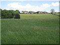
Pasture land on the edge of Edgworth
Seen from the path alongside the Wayoh reservoir.
Image: © Phil and Juliette Platt
Taken: 8 May 2011
0.10 miles

10
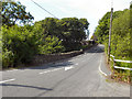
Hob Lane Bridge, Blackburn Road
Bridge crossing Wheatsheaf Brook
Image: © David Dixon
Taken: 14 Jul 2011
0.13 miles