IMAGES TAKEN NEAR TO
Knowsley Lane, BOLTON, BL7 0JH
Introduction
This page details the photographs taken nearby to Knowsley Lane, BL7 0JH by members of the Geograph project.
The Geograph project started in 2005 with the aim of publishing, organising and preserving representative images for every square kilometre of Great Britain, Ireland and the Isle of Man.

There are currently over 7.5m images from over14,400 individuals and you can help contribute to the project by visiting https://www.geograph.org.uk
Image Map
Images are licensed for reuse under creativecommons.org/licenses/by-sa/2.0
Notes
- Clicking on the map will re-center to the selected point.
- The higher the marker number, the further away the image location is from the centre of the postcode.
Image Listing (9 Images Found)
Images are licensed for reuse under creativecommons.org/licenses/by-sa/2.0
Image
Details
Distance
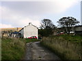
1
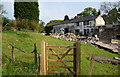
Cottage at the bottom of Knowsley Lane
The path goes through the left archway of the cottage. The extension on the right is a recent development.
Image: © Bill Boaden
Taken: 22 May 2010
0.06 miles
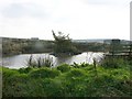
3

Broadhead Brook
Near the bottom of Knowsley Lane. It is more dried up than usual.
Image: © Bill Boaden
Taken: 22 May 2010
0.11 miles
4

Plastic duck on a pond
The Canada geese are real, but there were several plastic ducks of the mallard shape.
Image: © Bill Boaden
Taken: 22 May 2010
0.12 miles
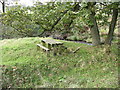
5

Broadhead Brook
This brook runs eventually into Wayoh Reservoir
Image: © liz dawson
Taken: 20 Oct 2007
0.13 miles
8
House on Knowsley Lane
Beware of the aggressive large dogs!
Image: © liz dawson
Taken: 20 Oct 2007
0.20 miles
9
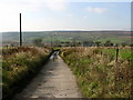
Knowsley Lane, Broadhead
The road leads off Broadhead Road opposite the Toby Inn
Image: © liz dawson
Taken: 20 Oct 2007
0.24 miles