IMAGES TAKEN NEAR TO
Plantation Road, BOLTON, BL7 0JE
Introduction
This page details the photographs taken nearby to Plantation Road, BL7 0JE by members of the Geograph project.
The Geograph project started in 2005 with the aim of publishing, organising and preserving representative images for every square kilometre of Great Britain, Ireland and the Isle of Man.

There are currently over 7.5m images from over14,400 individuals and you can help contribute to the project by visiting https://www.geograph.org.uk
Image Map
Images are licensed for reuse under creativecommons.org/licenses/by-sa/2.0
Notes
- Clicking on the map will re-center to the selected point.
- The higher the marker number, the further away the image location is from the centre of the postcode.
Image Listing (7 Images Found)
Images are licensed for reuse under creativecommons.org/licenses/by-sa/2.0
Image
Details
Distance
1
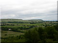
View South from north of Edgworth
The hills in the background are Quarlton Heights with the white buildings of Longshaw Head in front.
Holcommbe Hill is in the middle of the picture with the top of Peel Tower seen behind.
Bank Wood is in the forefront.
Image: © liz dawson
Taken: 23 Jun 2007
0.03 miles
2
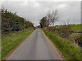
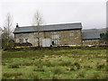
Plantation Road
Plantation Road, near Hazel Clough Farm.
Image: © David Dixon
Taken: 3 Oct 2011
0.11 miles
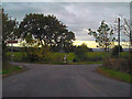
6
Broadhead Road
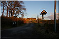
At its junction with Plantation Road south of Crowthorne.
Image: © philandju
Taken: 13 Aug 2020
0.21 miles