IMAGES TAKEN NEAR TO
Chapeltown Road, BOLTON, BL7 0HF
Introduction
This page details the photographs taken nearby to Chapeltown Road, BL7 0HF by members of the Geograph project.
The Geograph project started in 2005 with the aim of publishing, organising and preserving representative images for every square kilometre of Great Britain, Ireland and the Isle of Man.

There are currently over 7.5m images from over14,400 individuals and you can help contribute to the project by visiting https://www.geograph.org.uk
Image Map
Images are licensed for reuse under creativecommons.org/licenses/by-sa/2.0
Notes
- Clicking on the map will re-center to the selected point.
- The higher the marker number, the further away the image location is from the centre of the postcode.
Image Listing (8 Images Found)
Images are licensed for reuse under creativecommons.org/licenses/by-sa/2.0
Image
Details
Distance
1
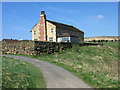
Torra Barn
A gentrified barn sitting in the middle of Turton Golf Course.
Image: © John Tustin
Taken: 18 Apr 2009
0.03 miles
2
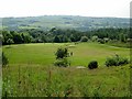
Turton Golf Course
A busy day at the club as the sun shines.
Image: © philandju
Taken: 7 Jun 2016
0.09 miles
3
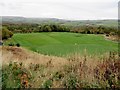
Overlooking a green on Turton golf course
A footpath runs through the golf course.
Image: © philandju
Taken: 23 Oct 2015
0.14 miles
4
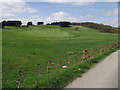
Turton Golf Course
Taken from the public footpath that runs alongside the course.
Image: © Phil Platt
Taken: 7 Apr 2011
0.15 miles
5
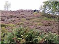
Bank of Heather
Autumn colours are to the fore.
Image: © philandju
Taken: 23 Oct 2015
0.19 miles
6
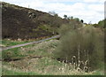
Path leading to Hazelhurst Wood
Following the perimeter of the golf course, one can climb to Cheetham Close, or take a right hand footpath to the wood.
Image: © Phil Platt
Taken: 7 Apr 2011
0.22 miles
7
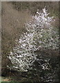
Spring Blossom
The tree almost seems to be covered in frost.
Image: © Phil Platt
Taken: 7 Apr 2011
0.23 miles
8
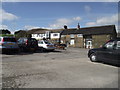
Club House, Turton Golf Club
A public footpath runs through the car park.
Image: © Phil Platt
Taken: 7 Apr 2011
0.24 miles