IMAGES TAKEN NEAR TO
Bury Road, BOLTON, BL7 0BR
Introduction
This page details the photographs taken nearby to Bury Road, BL7 0BR by members of the Geograph project.
The Geograph project started in 2005 with the aim of publishing, organising and preserving representative images for every square kilometre of Great Britain, Ireland and the Isle of Man.

There are currently over 7.5m images from over14,400 individuals and you can help contribute to the project by visiting https://www.geograph.org.uk
Image Map
Images are licensed for reuse under creativecommons.org/licenses/by-sa/2.0
Notes
- Clicking on the map will re-center to the selected point.
- The higher the marker number, the further away the image location is from the centre of the postcode.
Image Listing (3 Images Found)
Images are licensed for reuse under creativecommons.org/licenses/by-sa/2.0
Image
Details
Distance
1
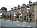
West View Terrace
This row of cottages was built in 1884, and called West View Terrace,
it is situated on Bury Road on the outskirts of Edgworth.
For more information about the village of Edgworth click on http://northturton.com/edgworth/edg_01.html
Image: © Paul Anderson
Taken: 26 Sep 2007
0.15 miles
3
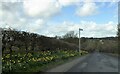
Bury Road approaching Edgworth
Spring daffodils brighten the roadside.
Image: © philandju
Taken: 24 Mar 2023
0.21 miles